No products
Categories
- Antique Maps and Views
- Africa
- America
- America (continent)
- Antilles (West Indies)
- Argentina
- Bermuda
- Brazil
- California
- Canada
- Central America and Antilles (West Indies)
- Chile
- Columbia
- Florida
- Guyana
- Hawaiian Islands
- Honduras
- Louisiana
- Mexico
- New Englang
- New York
- North America
- North Carolina
- Panama
- Paraguay
- Pennsylvania
- Peru
- South America
- Straits of Magellan
- United states (USA)
- Alabama
- Arkansas
- Boston
- Connecticut
- Florida
- Georgia
- Illinois
- Iowa
- Kentucky
- Louisiana
- Maine
- Maryland and Delaware
- Massachusetts and Rhode Island
- Michigan
- Mississippi
- Missouri
- New Hampshire and Vermont
- New Jersey
- New York
- Ohio
- Pennsylvania
- Philadelphia
- Rhode Island
- South Carolina
- Tennessee
- Texas
- U.S. East Coast
- Virginia
- Wisconsin
- Uruguay
- Venezuela
- Virginia
- Asia and Australia
- Asia (continent)
- Australia
- Burma
- China
- East Asia
- East Indies
- French Polynesia
- Gulf of Bengal
- India
- India, China, Nepal
- Indian ocean
- Indonesia
- Israel / Palestine
- Japan
- Korea
- Malaysia
- Micronesia
- Middle East
- New Zealand
- North-east Asia
- Pakistan
- Philippines
- Polynesia
- Southwest Asia
- Sri Lanka (Ceylon)
- The Caspian Sea
- Turkey
- Atlasy
- Europe
- Austria
- Baltic Sea
- Belgium, the Netherlands, Luxembourg
- Alkmaar
- Amsterdam
- Antwerp
- Arnhem
- Belgium and Luxembourg
- Bergen op Zoom
- Blokzijl
- Bommenede
- Brabant
- Breda
- Brielle
- Brugge
- Brussels
- Charleroi
- Courtrai
- Delft
- Dinant
- Dordrecht
- Drenthe
- Drenthe and Overijseel
- Elburg
- Flandres
- Fort Rammekens
- Friesland
- Friesland and Groningen
- Geertruidenberg
- Gelderland
- Geraardsbergen
- Grave
- Groningen
- Haarlem
- Hainaut
- Hannut
- Harderwijk
- Harlingen
- Holland
- Hulst
- Huy
- Leeuwarden
- Leiden
- Liége
- Lier
- Limbourg
- Limburg
- Louvain
- Luxemburg
- Luxemburg (city)
- Maastricht
- Mechelen
- Menin
- Middelburg
- Mons
- Namur
- Netherlands
- Netherlands and Belgium
- Nijmegen
- Ostend
- Overijssel
- Rotterdam
- Ruremonde
- s-Hertogenbosch
- Spa
- Stavoren
- Steenwijk
- The Hague
- Tiel
- Tournai
- Utrecht
- Veere
- Veurne
- Vlissingen
- Ypres
- Zaltbommel
- Zeeland
- Zieriksee
- Zierikzee
- Zutphen
- Zwolle
- Zype
- Bohemia, Moravia, Silesia and Lusatia
- Adršpach
- Andělská Hora (hrad)
- Bad Liebwerda
- Bechyňsko
- Bedřichov
- Beroun
- Berounsko
- Berounsko a Plzeňsko
- Bezděz
- Bílina
- Blansko
- Blatná
- Bohemia
- Bohemia, Moravia and Silesia
- Bolechovice
- Borotín
- Boskovice
- Bouzov
- Brandýs nad Labem
- Branná (okr. Šumperk)
- Břeclav
- Březnice
- Brněnsko
- Brněnsko a Uherskohardišťsko
- Brno
- Brodce (okr. Mladá Boleslav)
- Broumov
- Brtnice
- Budeč (hradiště)
- Buštěhrad
- Buzice (tvrz)
- Carlsbad
- Čáslav
- Čáslavsko
- Čelákovice
- Česká Lípa
- České Budějovice
- České Švýcarsko
- Český Brod
- Český Dub
- Český Krumlov
- Český Šternberk
- Cheb
- Chebsko a Loketsko
- Chebsko a Žatecko
- Chlum (okr. Kutná Hora)
- Chlum Svaté Máří
- Chlumec nad Cidlinou
- Chodová Planá
- Chomutov
- Choustníkovo Hradiště (zřícenina hradu)
- Chrudim
- Chrudimsko
- Chrudimsko, Čáslavsko, Kouřimsko
- Cornštejn
- Děčín
- Dívčí Hrad
- Doksany (okr. Litoměřice)
- Dolní Olešnice - Nové Zámky
- Dolní Životice (okr. Opava)
- Doupov
- Dubí
- Duchcov
- Dvojhradí (Mstišov)
- Dvůr Králové nad Labem
- Egerberk
- Egerberk (Klášterec nad Ohří)
- Felixburg (Klášterec nad Ohří)
- Františkovy Lázně
- Frenštát pod Radhošťem
- Frýdlant
- Habrovany
- Hartenberg (Hřebeny, okr. Sokolov)
- Hasištejn
- Hauenštejn (Horní hrad, okr. Karlovy Vary)
- Házmburk
- Helfštýn
- Hlavačov (Hlaváčov, Rakovník)
- Hluboká nad Vltavou
- Hořice (v Podkrkonoší)
- Hostinné
- Hradec Králové
- Hranice na Moravě
- Hřensko
- Hrubá Skála
- Hukvaldy
- Jáchymov
- Jankov
- Jánské Lázně
- Jánský Vrch
- Jánský Vrch (Javorník)
- Jaroměř
- Jenštejn
- Jeseník
- Jestřebí
- Jezeří
- Jičín
- Jihlava
- Jindřichův Hradec
- Jižní Čechy
- Kaceřov (Plzeň-sever)
- Kadaň
- Kamýk u Litoměřic
- Karlštejn
- Kasejovice - Řesanice
- Klabava (Ejpovice, okr. Rokycany)
- Kladno
- Kladruby
- Klatovy
- Kokořín
- Kolín
- Kondrac
- Konojedy (u Litoměřic)
- Konopiště
- Kopidlno (okr. Jičín)
- Kost
- Kostelec nad Labem
- Kostomlaty pod Milešovkou
- Kouřimsko
- Krakovec
- Králíky
- Královéhradecko
- Krásný Dvůr (okr. Louny)
- Krašov (hrad)
- Kratochvíle (zámek)
- Křečov (okr. Louny)
- Křepenice
- Křivoklát
- Krkonoše
- Krnov
- Kroměříž
- Krupka
- Krušné hory
- Kuks
- Kumburk
- Kunětická Hora
- Kunžvart (Šumava)
- Kutna Hora
- Kynšperk nad Ohří
- Kynžvart (zámek)
- Kyselka
- Kyšperk
- Lanšperk
- Ledeč nad Sázavou
- Lednice
- Libá (okr. Cheb)
- Libějovice
- Liberec
- Liběšice
- Liblín (okr. Rokycany)
- Libochovany
- Libochovice
- Libštejn
- Lina (Vroutek, okr. Louny)
- Lipnice nad Sázavou
- Litice
- Litoměřice
- Litoměřicko
- Litomyšl
- Loket
- Louny
- Lovosice
- Luhačovice
- Lužice
- Lysá nad Labem
- Mariánské Lázně
- Mělník
- Mikulov
- Milčany
- Milešov (Velemín)
- Milešovka
- Miletín
- Milíčeves (okr. Jičín)
- Mírov
- Mladá Boleslav
- Mladoboleslavsko
- Mladoboleslavsko a Litoměřicko
- Mnichovo Hradiště
- Moravia
- Most
- Mšec
- Náchod
- Napajedla
- Návarov
- Nelahozeves
- Nepomuk
- Nové Hrady (okr. Ústí nad Orlicí)
- Nový Bor
- Nymburk
- Okoř
- Olomouc
- Olomoucko
- Ondrášov (Moravský Beroun)
- Opava
- Orlík nad Vltavou
- Osek
- Ostrov nad Ohří
- Pacov
- Pardubice
- Pavlov
- Pecka (hrad)
- Pernštejn
- Petrohrad (Petršpurk, okr. Louny)
- Písek
- Plaňany
- Plasy
- Plzeň
- Plzeňsko
- Poděbrady
- Police
- Polná
- Prachatice
- Prácheňsko
- Prague
- Praha - Cheb
- Praha a okolí
- Přelouč
- Přerov
- Přerovsko
- Pressnitz
- Proboštov
- Proseč u Pošné (okr. Pelhřimov)
- Protivín
- Raabstein
- Rabí
- Račice (Vyškov)
- Radim (okr. Kolín)
- Rájec nad Svitavou
- Rajhrad
- Rakovnicko
- Rakovník
- Řečkovice
- Ronov (okr. Česká Lípa)
- Ronov nad Sázavou
- Roštejn
- Roudnice nad Labem
- Rožmberk nad Vltavou
- Rožnov pod Radhoštěm
- Rudolfov (České Budějovice)
- Rychmburk
- Rychnov nad Kněžnou
- Rýzmburk (hrad)
- Sedlec
- Šelmberk
- Severní Čechy
- Skuteč
- Slaný
- Slavkov u Brna
- Sloup (hrad)
- Smečno
- Smidary (okr. Hradec Králové)
- Smiřice
- Sovinec (hrad)
- Šternberk (Ledce)
- Štětí
- Strakonice
- Štramberk
- Střekov
- Šumava
- Šumburk (Šumná)
- Šumperk
- Švamberk (Krasíkov)
- Svatý Jan pod Skalou
- Svojanov (hrad)
- Svojšice
- Tábor
- Táborsko a Českobudějovicko
- Tachov
- Telenice - Varvažov
- Tepl
- Teplice
- Terezín
- Toužetín
- Třebel
- Třeboň
- Trhanov (okr. Domažlice)
- Trosky
- Tuchoraz
- Týn nad Vltavou
- Týnec nad Labem
- Uherské Hradiště
- Újezdec (hrad)
- Uničov
- Ústí nad Labem
- Úvaly
- Valdštejn
- Valkeřice
- Valtice
- Vartenberk - Stráž pod Ralskem (okr. Česká Lípa)
- Velehrad
- Velhartice
- Velké Meziříčí
- Velké Žernoseky
- Veveří
- Vimperk
- Vinec
- Višňová (okr. Liberec)
- Vlastislav
- Vlkava
- Vltava
- Vrabinec
- Vrchlabí
- Vřeskovice
- Východní a Severovýchodní Čechy
- Vysoké Mýto
- Vyšší Brod
- Žacléř
- Zahájí
- Zákupy
- Žampach (zámek)
- Zámrsk
- Západní Čechy
- Žatec
- Žatecko
- Žebrák a Točník
- Želiv
- Žireč
- Žleby
- Zlenice (Hláska)
- Znojemsko a Jihlavsko
- Znojmo
- Zvíkov
- Zvířetice
- Central Europe
- Danube
- Eastern and Southeastern Europe, Balkan
- Europe (continent)
- France
- Albi
- Anjou
- Arras
- Artois
- Auvergne
- Avignon
- Bar-le-Duc
- Beauce
- Beauvais
- Berry
- Blois
- Bordeaux
- Bourbonnais
- Bourbourg
- Bourgogne-Franche-Comté
- Bresse
- Brie
- Calais
- Cambrai
- Cassel
- Champagne
- Château de Lichtenberg
- Chaumont
- Compiegne and Noyon
- Corsica
- Dauphiné
- Dombes
- Douai
- Dunkerque
- Elsass
- Fontainebleau
- Gascogne
- Gâstinais and Senonais
- Gravelines
- Hauts-de-France
- Hondschoote
- Ile de France
- La Bassée - Hesdin
- La Rochelle
- Languedoc
- Lérins Islands
- Lille
- Limoges
- Lorraine
- Lyon
- Maine
- Marseille
- Metz
- Montmélian
- Mulhouse
- Nancy
- Nice
- Nivernais
- Normandie
- Orange
- Paris
- Perche
- Perpignan
- Picardy
- Poitou
- Provence
- Quercy
- Re and Oleron
- Reims - Rethel
- Rethel
- Saint-Germain-en-Laye
- Saint-Omer
- Saintonge and Aunis
- Sarlat
- Savoy
- Savoy and Eastern Burgundy (Franche - Comte)
- South France
- Southeast France
- Strasbourg
- Tarn (department)
- Thérouanne
- Touraine
- Valenciennes
- Vexin
- Western France
- Wissembourg
- Germany
- Great Britain and Ireland
- Bedford and Buckinghamshire
- Berkshire and Hampshire
- Cambridgeshire
- Cheshire
- Cornwall
- Cumberland
- Denbigh and Flint
- Derbyshire
- Devon
- Dorset
- Durham (County)
- England
- Essex
- Exeter
- Gloucestershire
- Great Britain and Ireland
- Hampshire
- Herefordshire
- Hertfordshire
- Hertfordshire and Middlesex
- Holy Island and Farne Island
- Huntingdonshire
- Ireland
- Isle of Man
- Isle of Wight
- Kent
- Lancashire
- Leicestershire
- Lincolnshire
- London
- Middlesex
- Norfolk
- Northampton
- Northeastern England
- Northern England
- Northumberland
- Northwestern England
- Nottinghamshire
- Orkney and Shetland
- Oxfordshire
- Portsmouth
- Rutland
- Scotland
- Shropshire
- Shropshire and Staffordshire
- Somerset
- Southeastern England
- Southwestern England
- Staffordshire
- Surrey
- Sussex
- Wales
- Westmorland
- Wiltshire
- Worcestershire and Warwickshire
- Yorkshire
- Greece, Mediterranean Sea
- Italy
- Abruzzo
- Acquapendente
- Ancona
- Apulia (Puglia)
- Arcevia
- Assisi
- Bari and Basilicata
- Belluno and Feltre
- Bergamo
- Bologna
- Bracciano
- Brescia
- Brescia and Crema
- Cadore
- Cagliari
- Caiazzo
- Calabria
- Camerino
- Campania
- Capitanata
- Carmagnola
- Catania
- Central Italy
- Civitavecchia
- Crema
- Cremona
- Cuneo
- Elba
- Emilia Romagna
- Faenza
- Fano
- Ferrara
- Florence
- Fondi
- Friuli
- Gaeta
- Gallipoli
- Genoa
- Ischia
- Italy
- Lago di Como
- Lago Maggiore
- Lazio
- Lerici
- Liguria (Italian Riviera)
- Livorno
- Lombardia
- Loreto
- Lucca
- Mantua
- Mantua
- Marche (Ancona)
- Merano
- Messina
- Milan
- Mirandola
- Modena
- Molise
- Monferrato
- Naples
- Netuno
- Nocera Umbra
- Northern Italy
- Orvieto
- Orvieto and Loreto
- Otranto
- Padua
- Palermo
- Parma
- Parma and Piacenza
- Pavia
- Perugia
- Pesaro
- Piacenza
- Piedmont
- Pinerolo
- Piombino
- Pisa
- Po
- Pozzuoli
- Puglia and Calabria
- Ravenna
- Reggio di Calabria
- Reggio Emilia
- Rimini
- Romagna
- Rome
- Rovereto
- Rovigo
- San Marino
- Sardinia
- Sicily
- Sicily and Malta
- Sicily and Sardinia
- Siena
- Southern Italy
- Spoleto
- Sulmona
- Taranto
- Terracina
- Tivoli
- Torino
- Tortona
- Trapani
- Trentino-Alto Adige / Südtirol
- Trento
- Treviso
- Tricarico
- Trieste
- Tuscany
- Tyrol
- Udine
- Umbria
- Urbino
- Velletri
- Venice
- Vercelli
- Verona
- Vicenza
- Viterbo
- Labe
- Mediterranean Sea
- Monaco
- Northern Europe
- Poland, Silesia, Russia and the Baltic republics
- Rhine
- Scandinavia and Iceland
- Spain and Portugal
- Andalucia
- Andalucia and Granada
- Aragon
- Azores
- Balearic Islands
- Barcelona
- Barcelona and Ecija
- Burgos
- Cadiz
- Canary Islands
- Castile
- Catalonia
- Cordoba
- Extremadura
- Galicia
- Gibraltar
- Granada
- Leon and Asturias
- Lisbon
- Madeira
- Madrid
- Navarra
- Northeastern Spain
- Northern Spain
- Northwestern Spain
- Portugal
- Roses
- Sevilla
- Spain
- Toledo and Valladolid
- Valencia
- Switzerland
- Islands (Special Catalogue)
- World, Oceans, Poles and Celestial Maps
- Books
- 17., 18. a 19. století - Bohemika, Moravika, České národní obrození
- 17th, 18th and 19th cent. - literature, illustrated etc. - foreign
- 20th cent. - literature, poetry, bibliophile books, illustrated etc. - foreign
- 20th cent. - literature, poetry, illustrated, bibliophile books, bookbindings etc. - Czech
- Children, youth and adventure books
- Fine arts & Architecture
- History and Law
- History of Culture, Varia
- Nature & Natural Sciences
- Old prints (15th and 16th century)
- Philosophy, Theology, Pedagogy, Economy, Sociology
- Topography, Travel and Geography
- Drawings and Prints
- Antique engravings, drawings and decorative prints
- Czech Art of 20th century (graphics, bookplates, drawings)
- Balcar, Jiří (1929-1968)
- Bílek, František (1872-1941)
- Bím, Tomáš (1946)
- Born, Adolf (1930)
- Bouda, Cyril (1901-1984)
- Chadima, Jiří (nar. 1923)
- Demel, Karel
- Fischerová-Kvěchová, Marie (1892-1984)
- Gross, František (1909-1985)
- Hodek, Josef mladší (1888-1973)
- Holler, Josef (1903-1982)
- Hudeček, František (1909-1990)
- Jiřincová, Ludmila (1912-1994)
- Kobliha, František (1877-1962)
- Konůpek, Jan (1883-1950)
- Lada, Josef (1887-1957)
- Lhoták, Kamil (1912-1990)
- Malich, Karel (1924-2019)
- Mrkvicka, Otakar (1898-1957)
- Mucha, Alfons
- Obrátil, Karel Jaroslav
- Orlik, Emil (1870-1932)
- Preissig, Vojtěch
- Rambousek, Jan (1895-1976)
- Sekora, Ondřej (1899-1967)
- Seydl, Zdenek (1916-1978)
- Šimon, Tavík František (1877-1942)
- Sladek, Jan (1906-1982)
- Stretti, Viktor (1878-1957)
- Stretti-Zamponi, Jaromír (1882-1959)
- Švabinský, Max (1873-1962)
- Tichý, František (1896-1961)
- Tomanová, Emilie (1933-1994)
- Trnka, Jiří (1912-1969)
- Uprka, Joža (1861-1940)
- Váchal, Josef (1884-1969)
- Vik, Karel (1883-1969)
- Vondrouš, Jan Charles (1884-1970)
- Wenig, Josef (1885-1939)
- Zrzavý, Jan (1890-1977)
- Devotional pictures, greeting cards etc.
- European modern art (graphics, bookplates, drawings)
- Japanese woodblocks
- Old-masters graphics
- Varia
List of works by author Homann, Johann Baptist
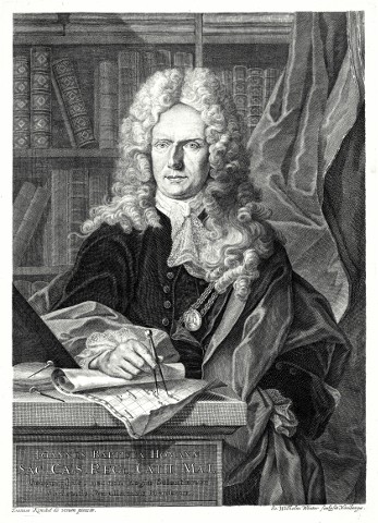
Johann Baptist Homann
Johann Baptist Homann (1664 in Oberkammlach, Bavaria - 1724 in Nuremberg) was a German cartographer, geographer, engraver and publisher.
He was educated in a Jesuit school, but converted to Protestantism and worked as a notary in Nuremberg from 1687. He soon turned to engraving and cartography, and in 1702 he founded his own publishing house, which focused on publishing cartographic works and veduta.
He soon became one of Germany's leading cartographers and in 1715 was appointed imperial geographer to Emperor Charles VI and a member of the Prussian Academy of Sciences in Berlin. Johann Baptist Homann died on 1 July 1724 in Nuremberg. His publishing house operated under the name Homann Erben until 1848.
- Homann, Johann Baptist Abbildung der Keysrl....Catalog No.: 00410
"Abbildung der Keysrl. Freyen-Reichs-Wahl-und-Handelstatt Franckfurt am Mayn mit ihrem Gebit und Gräntzen". Altkol. Grundriß mit Umgebung, darunter unkol. Prospekt (ca. 10:31 cm), flankiert von Allegorien sowie 2 kl. Detailans. (Keiserkrönung...
21 000,00 KčFor sale - Homann, Johann Baptist Accurate Vorstellung der Stadt CopenhagenCatalog No.: 12441
"Accurate Vorstellung der Berühmten Meer-Enge der Nord und Ost See der Sund genant, mit der herumliegenden Gegend von Seeland und Schonen, nebst der Königl-Dähnischen Hasupt und Residentz Stadt Copenhagen, so wohl in Grund als Prospect zu...
18 000,00 KčFor sale - Homann, Johann Baptist Accurater Grundris der Stadt MadritCatalog No.: 12456
"Accurater Grundris der Koenigl. Spanischen Haupt und Residentz Stadt Madrit". Orig. copper-engraving, J. B. Homann. Published by Homann Heirs in Nürnberg, ca. 1730. Orig. old colouring. With title above, a figure cartouche with the scale of...
18 000,00 KčFor sale - Homann, Johann Baptist Accurater Grundriß und Prospect Der Kön....Catalog No.: 19011
Stockholm. "Accurater Grundriß und Prospect Der ... Hauptstadt Stockholm". Orig. copperplate engraving, J. B. Homann, Nuremberg, ca. 1715. Original old colouring. With great figure title-cartouche. 47,5:57,5 cm.
12 000,00 KčFor sale - Homann, Johann Baptist Accurater Prospect u. Grundris der Gegend...Catalog No.: 00420
Weißenburg in Bayern. "Accurater Prospect u. Grundris der Gegend der Kayserl. Freyen Reichs Stadt Weissenburg am Nordgau". Orig. copperplate engraving. Published by J. B. Homann in Nuremberg, ca. 1720. Orig. old colouring. 49:56,5 cm.
7 500,00 KčFor sale - Homann, Johann Baptist Achaia Vetus et NovaCatalog No.: 02265
Attica (Athens). "Achaia Vetus et Nova". Orig. copperplate engraving, J. B. Homann, Nuremberg, ca. 1720. Orig. old colouring. 47,5:57 cm.
6 000,00 KčFor sale - Homann, Johann Baptist Amplissimae Regionis MississipiCatalog No.: 23665
United states (USA). "Amplissimae Regionis Mississipi Seu Provinciae Lidovicianae ... in America Septentrionali Anno 1687 detectae". Orig. copperplate engraving, J. B. Homann, ca. 1720. Orig. old colouring. With great figure title-cartouche with depiction of...
40 000,00 KčFor sale - Homann, Johann Baptist (author) Müller, Johann Christoph (other authors) Brňensko - Circuli Brunnensis pars...Catalog No.: 26953
Brněnsko. "Circuli Brunnensis pars Meridionalis". Pův., staře kol. mědirytina podle J. Ch. Müllerovy mapy. Vyd. J. B. Homann, ca. 1720. S titulem nad mapou a figurální kartuší s vysvětlivkami. 50:59,5 cm.
2 800,00 KčFor sale - Homann, Johann Baptist Crete - Insula Creta hodie Candia,...Catalog No.: 23374
Crete. "Insula Creta hodie Candia". Orig. copper-engraving, J. B. Homann, Nürnberg, ca. 1720. Original old colouring. With beautiful figure title cartouche, the scale of map and explanatory notes ("Signorum explicatio"). 48,5:58 cm.
9 500,00 KčFor sale - Homann, Johann Baptist Cursus Fluminis Padi vel Po per...Catalog No.: 07977
"Cursus Fluminis Padi vel Po per Longobardiam a fonte usque ad Ostia". Orig. copper-engraving published by Homann's Heirs, 1735. Orig. old colouring. With decorative title-cartouche and the scale of map. Printed from 2 plates. 51,5:116 cm (20 1/4...
25 000,00 KčFor sale - Homann, Johann Baptist Dominii Veneti cum vicinis Parmae Mutinae...Catalog No.: 02409
"Dominii Veneti cum vicinis Parmae Mutinae Mantuae et Mirandolae Statibus Nova Descriptio". Original copper plate engraving by Joahann Babtist Homann, printed ca. 1720. Original old colouring. With great figure cartouche with coat-of-arms. 49:58...
8 500,00 KčFor sale - Homann, Johann Baptist Ducatus Brabantiae Nova TabulaCatalog No.: 10620
"Ducatus Brabantiae Nova Tabula in qua Lovanii Bruxellarum March S. Imperii Sylvaeducis et Mechliniae Dominia". Original copper plate engraving by Johann Babtist Homann, printed ca. 1720. Original old colouring. With figure title cartouche with...
4 600,00 KčFor sale - Homann, Johann Baptist Ducatus BrunsuicensisCatalog No.: 09102
"Ducatus Brunsuicensis in tres Pricipatus Calenbergicum ..., Grubenhag & Gulepherbitanum ... divisi". Orig. copper-emgraving. Published by J. B. Homann, Nürnberg, ca. 1720. With great figure title-cartouche with 9 coats-of-arms and with many...
4 500,00 KčFor sale - Homann, Johann Baptist Ducatus Luneburgici et Comitatus...Catalog No.: 09099
"Ducatus Luneburgici et Comitatus Dannebergensis accurata Descriptio". Orig. copper-engraving published by J. B. Homann, Nürnberg, ca. 1710. With great figure title-cartouche with a coat-of arms and the scale of map. 48,5:57,5 cm (19 x 22 3/4...
4 800,00 KčFor sale - Homann, Johann Baptist Ducatus LuxemburgiCatalog No.: 06960
"Ducatus Luxemburgi tam in Maiores quam Minores ejusdem Ditiones accurate distinctus et exhibitus". Orig. copper-engraving. Published by J. B. Homann, ca. 1720. With figure title-cartouche with a coat-of-arms. 48:58 cm (19 x 28 3/4 inch.).
7 000,00 KčFor sale - Homann, Johann Baptist Ducatus MediolaniCatalog No.: 25245
Western Lombardy - Duchy of Milan. "Ducatus Mediolani". Orig. copperplate engraving, J. B. Homann, ca. 1715. Orig. old colouring. With figure title cartouche and the scale of map. 47:58,5 cm.
4 800,00 KčFor sale - Homann, Johann Baptist Ducatus Meklenburgici tabula generalisCatalog No.: 04252
"Ducatus Meklenburgici tabula generalis". Orig. altkol. Kupf-Kte bei J. B. Homann, 1712. Mit fig. Titelkart. und Meilenzeiger. 49:58 cm.
4 800,00 KčFor sale - Homann, Johann Baptist Ducatus WürtenbergiciCatalog No.: 00326
Württemberg. "Ducatus Würtenbergici". Orig. copperplate engraving, J. B. Homann, ca. 1710. Orig. old colouring. With 2 figure and herald. cartouches with small views of Stuttgart and Tübingen and total 76 coats of arms by the sides. 57,5:95 cm.
12 000,00 KčFor sale - Homann, Johann Baptist Eigentliche Verzeichnung der Gegend und...Catalog No.: 00421
Eichstätt. "Eigentliche Verzeichnung der Gegend und Prospecten der ... Stadt Aichstaedt". Orig. copperplate engraving. Published by Homann Heirs in Nuremberg, 1730. Orig. old colouring. 50:58,5 cm.
14 500,00 KčFor sale - Homann, Johann Baptist Episcopatus Hildesiensis nec non vicinorum...Catalog No.: 01660
Hildesheim. "Episcopatus Hildesiensis nec non vicinorum Statuum delineatio Geographica ...". Altkol. Kupf.-Kte. nach Gerhard Iust. Arenhold bei J. B. Homann, (um 1720). Unten rechts Titelkartusche. Unten mitten Gesamtansicht von der Stadt Hildesheim. Unten...
4 200,00 KčFor sale - Homann, Johann Baptist Frankfurt nad Mohanem - Abbildung der...Catalog No.: 00411
Frankfurt am Main. "Abbildung der Keysrl. ... Handelstatt Franckfurt am Mayn mit ihrem Gebiet und Gräntzen". Orig. copperplate engraving, J. B. Homann, ca. 1715. Orig. old colouring. 50:58,5 cm.
10 500,00 KčFor sale - Homann, Johann Baptist Hodierna Sedes Electoris Palatini ManheimiumCatalog No.: 00413
Mannheim. "Hodierna Sedes Electoris Palatini Manheimium". Orig. copperplate engraving. Published by Homann Heirs in Nuremberg, ca. 1730. Orig. old colouring. 48:57,5 cm.
15 000,00 KčFor sale - Homann, Johann Baptist Insularum Maltae et GozaeCatalog No.: 25345
Malta, Gozo, Comino. "Insularum Maltae et Gozae ... Delineatio Geographica". Orig. copperplate engraving, J. B. Homann, ca. 1720. Original old colouring. With great figure title cartouche and inset fortification plan and a panoramic view of Valletta. 48,5:58 cm.
45 000,00 KčFor sale - Homann, Johann Baptist (author) Müller, Johann Christoph (other authors) Kouřimský kraj - Regni Bohemiae Circulus...Catalog No.: 26713
Kouřimsko. "Regni Bohemiae Circulus Kaurzimensis". Původní, staře kolorovaná mědirytina podle J. Ch. Müllerovy mapy regionu. Homannovi dědicové, Norimberk, 1773. S ornament. tit. kartuší. 49,5:56 cm.
5 400,00 KčFor sale - Homann, Johann Baptist (author) Nolli, Giambattista (other authors) Languedoc - Gubernatio Generalis...Catalog No.: 11310
Languedoc. "Gubernatio Generalis Languedociae". Orig. copperplate engraving after G. Nolli's map of the region. Published in Nuremberg by Homann Heirs, 1742. Orig. old colouring. 49:57,5 cm.
4 000,00 KčFor sale - Homann, Johann Baptist (author) Müller, Johann Christoph (other authors) Morava - Tabula Generalis Marchionatus...Catalog No.: 26950
Morava. "Tabula Generalis Marchionatus Moraviae in sex circulos divisae". Pův., staře kolorovaná mědirytina podle J. Ch. Müllerovy mapy Moravy. Vyd. J. B. Homann v Norimberku, ca. 1720. S velkou figurální kartuší s erbem. 48,5:58,5 cm.
2 800,00 KčFor sale - Homann, Johann Baptist Nova et accurata Territorii Ulmensis cum...Catalog No.: 00329
Ulm. "Nova et accurata Territorii Ulmensis cum Dominio Wainensi Descriptio". Orig. copper-engraving, Johann Baptist Homann (1663-1724), ca. 1720 in Nurnberg. Original old colouring. 48,5:57 cm.
5 200,00 KčFor sale - Homann, Johann Baptist Nova Tabula ScaniaeCatalog No.: 01142
South Sweden. "Nova Tabula Scaniae,". Orig. copperplate engraving, J. B. Homann, ca. 1720. Orig. old colouring. With figure title cartouche and an inset map of the northern part of Halland province. 47,5:56,5 cm.
6 500,00 KčFor sale - Homann, Johann Baptist Nova Territorii Erfordiensis ... descriptioCatalog No.: 00325
Erfurt. "Nova Territorii Erfordiensis in suas Praefecturas accuratie divisi descriptio cui accedit Erfordiae Urbis ...". Altkol. Kupf.-Karte von J. B. Homann, (1712). Unten rechts große fig. Titelkartusche mit einem Wappen. Unter der Karte Gesamtansicht...
4 500,00 KčFor sale - Homann, Johann Baptist (author) Müller, Johann Christoph (other authors) Olomoucko - Circuli Olomucensis pars...Catalog No.: 26952
Olomoucko - severní část. "Circuli Olomucensis pars Borealis". Pův., staře kol. mědirytina podle J. Ch. Müllerovy mapy. Vyd. J. B. Homann v Norimbarku, ca. 1720. 48:58 cm.
2 800,00 KčFor sale - Homann, Johann Baptist Parma and Piacenza - Status Parmensis sive...Catalog No.: 04974
Parma and Piacenza. "Status Parmensis sive Ducatus Parmensis et Placentinus una cum Ditione Buxetana et Valle Tarae Novissime exhibitus". Orig. copperplate engraving published by Homann Heirs, 1731. Original old colouring. 48:56,5 cm.
9 500,00 KčFor sale - Homann, Johann Baptist Plan de la place de CorfuCatalog No.: 25319
Corfu (Greece). "Plan de la place de Corfu". Orig. copperplate engraving, J. B. Homann, Nuremberg, 1716. With great figure cartouche and decorative border. 48,5:56 cm.
15 000,00 KčSold - Homann, Johann Baptist Plan der Belagerung von FridrichshallCatalog No.: 12453
"Plan der Belagerung von Fridrichshall angefangen von Carl dem XII ... d. 11. Nov: aufgehoben d. 12. Dec. 1718". Orig. copper-engraving, J. B. Homann, Nürnberg, ca. 1720. Orig. old colouring. With great decorative title-cartouche above and a...
16 000,00 KčFor sale - Homann, Johann Baptist Plan du Mayence - Accurater Plan der...Catalog No.: 00416
Mainz. "Plan du Mayence - Accurater Plan der ... Stadt Maynz". Orig. copperplate engraving. Published by Homann Heirs in Nuremberg, ca. 1735. Orig. old colouring. 58:48 cm.
11 000,00 KčFor sale - Homann, Johann Baptist Plan du Siege de CorfuCatalog No.: 24374
Corfu. "Plan du Siege de Corfu". Orig. copperplate engraving, J. B. Homann, Nürnberg, ca. 1720. Orig. old colouring. With great figure cartouche and decorative border with title, explanatory notes, 4 inset detailed plans and a coat of arms. 48:55,5 cm.
12 500,00 KčFor sale - Homann, Johann Baptist (author) Müller, Johann Christoph (other author) Přerovsko - Marchionatus Moraviae Circulus...Catalog No.: 26951
Přerovsko. "Marchionatus Moraviae Circulus Preroviensis ... pars Borealis". Původní, staře kol. mědirytina podle J. Ch. Müllerovy mapy. Vyd. J. B. Homann, ca. 1720. S velkou figurální tit. kartuší. 47:57,5 cm.
2 800,00 KčFor sale - Homann, Johann Baptist (author) Müller, Johann Christoph (other authors) Přerovsko - Marchionatus Moraviae Circulus...Catalog No.: 26686
Přerovsko (Severní Morava). "Marchionatus Moraviae Circulus Preroviensis". Původní, staře kolorovaná mědirytina podle J. Ch. Müllerovy mapy regionu. Vyd. J. B. Homann, ca. 1720. S velkou figurální tit. kartuší. 83,5:58 cm.
7 500,00 KčFor sale - Homann, Johann Baptist Prospect und Grundris der Stadt Bremen...Catalog No.: 00405
Bremen. "Prospect und Grundris der ... Stadt Bremen samt ihrer Gegend". Orig. copperplate engraving, J. B. Homann, Nuremberg, ca. 1720. Orig. old colouring. 48:57,5 cm.
16 000,00 KčFor sale - Homann, Johann Baptist Prospect, Grundris und Gegent der Königl....Catalog No.: 00295
"Prospect, Grundris und Gegent der Königl. Schwed. Vestung Stralsund wie solche den 15 July 1715 von den Nordischen Hohen Allyrten ist belagert worden". Altkol. Kupf.-Kte. nach D. Heer bei J. B. Homann, (1716). Umgebungskte. von Stralsund mit...
11 000,00 KčFor sale - Homann, Johann Baptist Protoparchiae Mindelhemensis Nova Tabula...Catalog No.: 01579
"Protoparchiae Mindelhemensis Nova Tabula Geographica ...". Altkol. Kupf.-Kte. bei J. B. Homann, (um 1720). Oben links von Putten gehaltene Titelkartusche. Rechts Kartusche mit Ansicht von der Stadt Mindelheim. 49:58,5 cm.
6 800,00 KčFor sale - Homann, Johann Baptist Regni Mexicani seu Novae Hispaniae,...Catalog No.: 00094
North America, Mexico and the Caribbean. "Regni Mexicani seu Novae Hispaniae, Floridae, Novae Angliae, Carolinae, Virginiae, et Pennsylvaniae, nec non Insularum Archipelagi Mexicani in America Septentrionali accurata Tabula". Orig. copper-engraving, published by J. B....
21 000,00 KčFor sale - Homann, Johann Baptist Regni Norvegiae accurata tabulaCatalog No.: 01232
"Regni Norvegiae accurata tabula". Orig. copper-engraving published by J. B. Homann, published ca. 1720. Old colouring. With coloured side-map of northern part of Norway ("Norvegiae pars septentrionalis ...") and two figure and ornamental cartouches. 57,5:49,5...
14 000,00 KčFor sale - Homann, Johann Baptist Regni SueciaeCatalog No.: 01139
Sweden, Finland, St. Petersburg, Estonia. "Regni Sueciae". Orig. copperplate engraving published by J. B. Homann, ca. 1720. Orig. old colouring. With figure title cartouche with a coat of arms. 49:57,5 cm.
4 500,00 KčFor sale - Homann, Johann Baptist Regnorum Siciliae et Sardiniae ... MaltaeCatalog No.: 22856
Sicily and Sardina. "Regnorum Siciliae et Sardiniae nec non Melitae seu Maltae Insulae ...". Original copper-engraving, J. B. Homann, ca. 1720. Original old colouring. With great figure title cartouche with 2 coats-of-arms, a cartouche with inset plan of Catania with Mt. Etna in the background, another cartouche with inset fotification plan of Valletta....
15 000,00 KčFor sale - Homann, Johann Baptist S.R.I. Circulus SueviaeCatalog No.: 02166
Baden-Württemberg. "S.R.I. Circulus Sueviae continens Ducatum Wirtenbergensem ...". Orig. copperplate engraving, Johann Baptist Homann, Nurnberg, ca. 1710. Original old colouring. With two pictorial figurative cartouches. 49:56 cm (19 1/4 x...
4 200,00 KčFor sale - Homann, Johann Baptist (author) Valvasor, Johann Weichard von (other authors) Slovenia, Istria, Lubljana - Tabula...Catalog No.: 22863
Slovenia, Istria, Lubljana. "Tabula Ducatus Carnioliae Vindorum Marchiae et Histriae". Orig. copperplate engraving after J. V. Valvasor's map of the region. Published by J. B. Homann, Nuremberg, ca. 1720. Original old colouring. With great figure and heraldic tile-cartouche, small inset map of Cerknica Lake and inset view of Ljubljana. 48:58 cm.
10 500,00 KčFor sale - Homann, Johann Baptist Statuum Maroccanorum RegnorumCatalog No.: 00437
Morocco and Canary Islands. "Statuum Maroccanorum Regnorum". Orig. copper-engraving, J. B. Homann, 1728 in Nuremberg. Original old colouring. With great figure title cartouche and views of Marrakesh and Méknes (each one 11:27 cm) at the bottom. 48,5:56 cm.
6 500,00 KčFor sale - Homann, Johann Baptist StralsundCatalog No.: 07521
"Stralsund". Altkol. Kupferstich bei J. B. Homann, um 1720. Mit gest. Titel, ornament. Kart. mit "Erklaerung der Zieffer" und vielen Schieffe. 23,5:26 cm.
2 100,00 KčFor sale - Homann, Johann Baptist Tabula Delphinatus Vulgo le Gouvernement...Catalog No.: 02160
French Alps (Grenoble). "Tabula Delphinatus Vulgo le Gouvernement general du Dauphiné". Orig. copperplate engraving, Johann Baptist Homann, Nuremberg, 1710 after Tillemon(t)'s map. 48:57 cm.
4 000,00 KčFor sale - Homann, Johann Baptist Tabula Generalis Holsatiae complectens...Catalog No.: 02175
Holstein (Hamburg). "Tabula Generalis Holsatiae complectens Holsatiae Dithmarsiae Stormariae et Vagriae Ducatus". Orig. copperplate engraving, Johann Baptist Homann, Nuremberg, ca. 1710. Original old colouring. 48:57,5 cm.
4 000,00 KčFor sale


