No products
Categories
- Antique Maps and Views
- Africa
- America
- America (continent)
- Antilles (West Indies)
- Argentina
- Bermuda
- Brazil
- California
- Canada
- Central America and Antilles (West Indies)
- Chile
- Columbia
- Florida
- Guyana
- Hawaiian Islands
- Honduras
- Louisiana
- Mexico
- New Englang
- New York
- North America
- North Carolina
- Panama
- Paraguay
- Pennsylvania
- Peru
- South America
- Straits of Magellan
- United states (USA)
- Alabama
- Arkansas
- Boston
- Connecticut
- Florida
- Georgia
- Illinois
- Iowa
- Kentucky
- Louisiana
- Maine
- Maryland and Delaware
- Massachusetts and Rhode Island
- Michigan
- Mississippi
- Missouri
- New Hampshire and Vermont
- New Jersey
- New York
- Ohio
- Pennsylvania
- Philadelphia
- Rhode Island
- South Carolina
- Tennessee
- Texas
- U.S. East Coast
- Virginia
- Wisconsin
- Uruguay
- Venezuela
- Virginia
- Asia and Australia
- Asia (continent)
- Australia
- Burma
- China
- East Asia
- East Indies
- French Polynesia
- Gulf of Bengal
- India
- India, China, Nepal
- Indian ocean
- Indonesia
- Israel / Palestine
- Japan
- Korea
- Malaysia
- Micronesia
- Middle East
- New Zealand
- North-east Asia
- Pakistan
- Philippines
- Polynesia
- Southwest Asia
- Sri Lanka (Ceylon)
- The Caspian Sea
- Turkey
- Atlasy
- Europe
- Austria
- Baltic Sea
- Belgium, the Netherlands, Luxembourg
- Alkmaar
- Amsterdam
- Antwerp
- Arnhem
- Belgium and Luxembourg
- Bergen op Zoom
- Blokzijl
- Bommenede
- Brabant
- Breda
- Brielle
- Brugge
- Brussels
- Charleroi
- Courtrai
- Delft
- Dinant
- Dordrecht
- Drenthe
- Drenthe and Overijseel
- Elburg
- Flandres
- Fort Rammekens
- Friesland
- Friesland and Groningen
- Geertruidenberg
- Gelderland
- Geraardsbergen
- Grave
- Groningen
- Haarlem
- Hainaut
- Hannut
- Harderwijk
- Harlingen
- Holland
- Hulst
- Huy
- Leeuwarden
- Leiden
- Liége
- Lier
- Limbourg
- Limburg
- Louvain
- Luxemburg
- Luxemburg (city)
- Maastricht
- Mechelen
- Menin
- Middelburg
- Mons
- Namur
- Netherlands
- Netherlands and Belgium
- Nijmegen
- Ostend
- Overijssel
- Rotterdam
- Ruremonde
- s-Hertogenbosch
- Spa
- Stavoren
- Steenwijk
- The Hague
- Tiel
- Tournai
- Utrecht
- Veere
- Veurne
- Vlissingen
- Ypres
- Zaltbommel
- Zeeland
- Zieriksee
- Zierikzee
- Zutphen
- Zwolle
- Zype
- Bohemia, Moravia, Silesia and Lusatia
- Adršpach
- Andělská Hora (hrad)
- Bad Liebwerda
- Bechyňsko
- Bedřichov
- Beroun
- Berounsko
- Berounsko a Plzeňsko
- Bezděz
- Bílina
- Blansko
- Blatná
- Bohemia
- Bohemia, Moravia and Silesia
- Bolechovice
- Borotín
- Boskovice
- Bouzov
- Brandýs nad Labem
- Branná (okr. Šumperk)
- Břeclav
- Březnice
- Brněnsko
- Brněnsko a Uherskohardišťsko
- Brno
- Brodce (okr. Mladá Boleslav)
- Broumov
- Brtnice
- Budeč (hradiště)
- Buštěhrad
- Buzice (tvrz)
- Carlsbad
- Čáslav
- Čáslavsko
- Čelákovice
- Česká Lípa
- České Budějovice
- České Švýcarsko
- Český Brod
- Český Dub
- Český Krumlov
- Český Šternberk
- Cheb
- Chebsko a Loketsko
- Chebsko a Žatecko
- Chlum (okr. Kutná Hora)
- Chlum Svaté Máří
- Chlumec nad Cidlinou
- Chodová Planá
- Chomutov
- Choustníkovo Hradiště (zřícenina hradu)
- Chrudim
- Chrudimsko
- Chrudimsko, Čáslavsko, Kouřimsko
- Cornštejn
- Děčín
- Dívčí Hrad
- Doksany (okr. Litoměřice)
- Dolní Olešnice - Nové Zámky
- Dolní Životice (okr. Opava)
- Doupov
- Dubí
- Duchcov
- Dvojhradí (Mstišov)
- Dvůr Králové nad Labem
- Egerberk
- Egerberk (Klášterec nad Ohří)
- Felixburg (Klášterec nad Ohří)
- Františkovy Lázně
- Frenštát pod Radhošťem
- Frýdlant
- Habrovany
- Hartenberg (Hřebeny, okr. Sokolov)
- Hasištejn
- Hauenštejn (Horní hrad, okr. Karlovy Vary)
- Házmburk
- Helfštýn
- Hlavačov (Hlaváčov, Rakovník)
- Hluboká nad Vltavou
- Hořice (v Podkrkonoší)
- Hostinné
- Hradec Králové
- Hranice na Moravě
- Hřensko
- Hrubá Skála
- Hukvaldy
- Jáchymov
- Jankov
- Jánské Lázně
- Jánský Vrch
- Jánský Vrch (Javorník)
- Jaroměř
- Jenštejn
- Jeseník
- Jestřebí
- Jezeří
- Jičín
- Jihlava
- Jindřichův Hradec
- Jižní Čechy
- Kaceřov (Plzeň-sever)
- Kadaň
- Kamýk u Litoměřic
- Karlštejn
- Kasejovice - Řesanice
- Klabava (Ejpovice, okr. Rokycany)
- Kladno
- Kladruby
- Klatovy
- Kokořín
- Kolín
- Kondrac
- Konojedy (u Litoměřic)
- Konopiště
- Kopidlno (okr. Jičín)
- Kost
- Kostelec nad Labem
- Kostomlaty pod Milešovkou
- Kouřimsko
- Krakovec
- Králíky
- Královéhradecko
- Krásný Dvůr (okr. Louny)
- Krašov (hrad)
- Kratochvíle (zámek)
- Křečov (okr. Louny)
- Křepenice
- Křivoklát
- Krkonoše
- Krnov
- Kroměříž
- Krupka
- Krušné hory
- Kuks
- Kumburk
- Kunětická Hora
- Kunžvart (Šumava)
- Kutna Hora
- Kynšperk nad Ohří
- Kynžvart (zámek)
- Kyselka
- Kyšperk
- Lanšperk
- Ledeč nad Sázavou
- Lednice
- Libá (okr. Cheb)
- Libějovice
- Liberec
- Liběšice
- Liblín (okr. Rokycany)
- Libochovany
- Libochovice
- Libštejn
- Lina (Vroutek, okr. Louny)
- Lipnice nad Sázavou
- Litice
- Litoměřice
- Litoměřicko
- Litomyšl
- Loket
- Louny
- Lovosice
- Luhačovice
- Lužice
- Lysá nad Labem
- Mariánské Lázně
- Mělník
- Mikulov
- Milčany
- Milešov (Velemín)
- Milešovka
- Miletín
- Milíčeves (okr. Jičín)
- Mírov
- Mladá Boleslav
- Mladoboleslavsko
- Mladoboleslavsko a Litoměřicko
- Mnichovo Hradiště
- Moravia
- Most
- Mšec
- Náchod
- Napajedla
- Návarov
- Nelahozeves
- Nepomuk
- Nové Hrady (okr. Ústí nad Orlicí)
- Nový Bor
- Nymburk
- Okoř
- Olomouc
- Olomoucko
- Ondrášov (Moravský Beroun)
- Opava
- Orlík nad Vltavou
- Osek
- Ostrov nad Ohří
- Pacov
- Pardubice
- Pavlov
- Pecka (hrad)
- Pernštejn
- Petrohrad (Petršpurk, okr. Louny)
- Písek
- Plaňany
- Plasy
- Plzeň
- Plzeňsko
- Poděbrady
- Police
- Polná
- Prachatice
- Prácheňsko
- Prague
- Praha - Cheb
- Praha a okolí
- Přelouč
- Přerov
- Přerovsko
- Pressnitz
- Proboštov
- Proseč u Pošné (okr. Pelhřimov)
- Protivín
- Raabstein
- Rabí
- Račice (Vyškov)
- Radim (okr. Kolín)
- Rájec nad Svitavou
- Rajhrad
- Rakovnicko
- Rakovník
- Řečkovice
- Ronov (okr. Česká Lípa)
- Ronov nad Sázavou
- Roštejn
- Roudnice nad Labem
- Rožmberk nad Vltavou
- Rožnov pod Radhoštěm
- Rudolfov (České Budějovice)
- Rychmburk
- Rychnov nad Kněžnou
- Rýzmburk (hrad)
- Sedlec
- Šelmberk
- Severní Čechy
- Skuteč
- Slaný
- Slavkov u Brna
- Sloup (hrad)
- Smečno
- Smidary (okr. Hradec Králové)
- Smiřice
- Sovinec (hrad)
- Šternberk (Ledce)
- Štětí
- Strakonice
- Štramberk
- Střekov
- Šumava
- Šumburk (Šumná)
- Šumperk
- Švamberk (Krasíkov)
- Svatý Jan pod Skalou
- Svojanov (hrad)
- Svojšice
- Tábor
- Táborsko a Českobudějovicko
- Tachov
- Telenice - Varvažov
- Tepl
- Teplice
- Terezín
- Toužetín
- Třebel
- Třeboň
- Trhanov (okr. Domažlice)
- Trosky
- Tuchoraz
- Týn nad Vltavou
- Týnec nad Labem
- Uherské Hradiště
- Újezdec (hrad)
- Uničov
- Ústí nad Labem
- Úvaly
- Valdštejn
- Valkeřice
- Valtice
- Vartenberk - Stráž pod Ralskem (okr. Česká Lípa)
- Velehrad
- Velhartice
- Velké Meziříčí
- Velké Žernoseky
- Veveří
- Vimperk
- Vinec
- Višňová (okr. Liberec)
- Vlastislav
- Vlkava
- Vltava
- Vrabinec
- Vrchlabí
- Vřeskovice
- Východní a Severovýchodní Čechy
- Vysoké Mýto
- Vyšší Brod
- Žacléř
- Zahájí
- Zákupy
- Žampach (zámek)
- Zámrsk
- Západní Čechy
- Žatec
- Žatecko
- Žebrák a Točník
- Želiv
- Žireč
- Žleby
- Zlenice (Hláska)
- Znojemsko a Jihlavsko
- Znojmo
- Zvíkov
- Zvířetice
- Central Europe
- Danube
- Eastern and Southeastern Europe, Balkan
- Europe (continent)
- France
- Albi
- Anjou
- Arras
- Artois
- Auvergne
- Avignon
- Bar-le-Duc
- Beauce
- Beauvais
- Berry
- Blois
- Bordeaux
- Bourbonnais
- Bourbourg
- Bourgogne-Franche-Comté
- Bresse
- Brie
- Calais
- Cambrai
- Cassel
- Champagne
- Château de Lichtenberg
- Chaumont
- Compiegne and Noyon
- Corsica
- Dauphiné
- Dombes
- Douai
- Dunkerque
- Elsass
- Fontainebleau
- Gascogne
- Gâstinais and Senonais
- Gravelines
- Hauts-de-France
- Hondschoote
- Ile de France
- La Bassée - Hesdin
- La Rochelle
- Languedoc
- Lérins Islands
- Lille
- Limoges
- Lorraine
- Lyon
- Maine
- Marseille
- Metz
- Montmélian
- Mulhouse
- Nancy
- Nice
- Nivernais
- Normandie
- Orange
- Paris
- Perche
- Perpignan
- Picardy
- Poitou
- Provence
- Quercy
- Re and Oleron
- Reims - Rethel
- Rethel
- Saint-Germain-en-Laye
- Saint-Omer
- Saintonge and Aunis
- Sarlat
- Savoy
- Savoy and Eastern Burgundy (Franche - Comte)
- South France
- Southeast France
- Strasbourg
- Tarn (department)
- Thérouanne
- Touraine
- Valenciennes
- Vexin
- Western France
- Wissembourg
- Germany
- Great Britain and Ireland
- Bedford and Buckinghamshire
- Berkshire and Hampshire
- Cambridgeshire
- Cheshire
- Cornwall
- Cumberland
- Denbigh and Flint
- Derbyshire
- Devon
- Dorset
- Durham (County)
- England
- Essex
- Exeter
- Gloucestershire
- Great Britain and Ireland
- Hampshire
- Herefordshire
- Hertfordshire
- Hertfordshire and Middlesex
- Holy Island and Farne Island
- Huntingdonshire
- Ireland
- Isle of Man
- Isle of Wight
- Kent
- Lancashire
- Leicestershire
- Lincolnshire
- London
- Middlesex
- Norfolk
- Northampton
- Northeastern England
- Northern England
- Northumberland
- Northwestern England
- Nottinghamshire
- Orkney and Shetland
- Oxfordshire
- Portsmouth
- Rutland
- Scotland
- Shropshire
- Shropshire and Staffordshire
- Somerset
- Southeastern England
- Southwestern England
- Staffordshire
- Surrey
- Sussex
- Wales
- Westmorland
- Wiltshire
- Worcestershire and Warwickshire
- Yorkshire
- Greece, Mediterranean Sea
- Italy
- Abruzzo
- Acquapendente
- Ancona
- Apulia (Puglia)
- Arcevia
- Assisi
- Bari and Basilicata
- Belluno and Feltre
- Bergamo
- Bologna
- Bracciano
- Brescia
- Brescia and Crema
- Cadore
- Cagliari
- Caiazzo
- Calabria
- Camerino
- Campania
- Capitanata
- Carmagnola
- Catania
- Central Italy
- Civitavecchia
- Crema
- Cremona
- Cuneo
- Elba
- Emilia Romagna
- Faenza
- Fano
- Ferrara
- Florence
- Fondi
- Friuli
- Gaeta
- Gallipoli
- Genoa
- Ischia
- Italy
- Lago di Como
- Lago Maggiore
- Lazio
- Lerici
- Liguria (Italian Riviera)
- Livorno
- Lombardia
- Loreto
- Lucca
- Mantua
- Mantua
- Marche (Ancona)
- Merano
- Messina
- Milan
- Mirandola
- Modena
- Molise
- Monferrato
- Naples
- Netuno
- Nocera Umbra
- Northern Italy
- Orvieto
- Orvieto and Loreto
- Otranto
- Padua
- Palermo
- Parma
- Parma and Piacenza
- Pavia
- Perugia
- Pesaro
- Piacenza
- Piedmont
- Pinerolo
- Piombino
- Pisa
- Po
- Pozzuoli
- Puglia and Calabria
- Ravenna
- Reggio di Calabria
- Reggio Emilia
- Rimini
- Romagna
- Rome
- Rovereto
- Rovigo
- San Marino
- Sardinia
- Sicily
- Sicily and Malta
- Sicily and Sardinia
- Siena
- Southern Italy
- Spoleto
- Sulmona
- Taranto
- Terracina
- Tivoli
- Torino
- Tortona
- Trapani
- Trentino-Alto Adige / Südtirol
- Trento
- Treviso
- Tricarico
- Trieste
- Tuscany
- Tyrol
- Udine
- Umbria
- Urbino
- Velletri
- Venice
- Vercelli
- Verona
- Vicenza
- Viterbo
- Labe
- Mediterranean Sea
- Monaco
- Northern Europe
- Poland, Silesia, Russia and the Baltic republics
- Rhine
- Scandinavia and Iceland
- Spain and Portugal
- Andalucia
- Andalucia and Granada
- Aragon
- Azores
- Balearic Islands
- Barcelona
- Barcelona and Ecija
- Burgos
- Cadiz
- Canary Islands
- Castile
- Catalonia
- Cordoba
- Extremadura
- Galicia
- Gibraltar
- Granada
- Leon and Asturias
- Lisbon
- Madeira
- Madrid
- Navarra
- Northeastern Spain
- Northern Spain
- Northwestern Spain
- Portugal
- Roses
- Sevilla
- Spain
- Toledo and Valladolid
- Valencia
- Switzerland
- Islands (Special Catalogue)
- World, Oceans, Poles and Celestial Maps
- Books
- 17., 18. a 19. století - Bohemika, Moravika, České národní obrození
- 17th, 18th and 19th cent. - literature, illustrated etc. - foreign
- 20th cent. - literature, poetry, bibliophile books, illustrated etc. - foreign
- 20th cent. - literature, poetry, illustrated, bibliophile books, bookbindings etc. - Czech
- Children, youth and adventure books
- Fine arts & Architecture
- History and Law
- History of Culture, Varia
- Nature & Natural Sciences
- Old prints (15th and 16th century)
- Philosophy, Theology, Pedagogy, Economy, Sociology
- Topography, Travel and Geography
- Drawings and Prints
- Antique engravings, drawings and decorative prints
- Czech Art of 20th century (graphics, bookplates, drawings)
- Balcar, Jiří (1929-1968)
- Bílek, František (1872-1941)
- Bím, Tomáš (1946)
- Born, Adolf (1930)
- Bouda, Cyril (1901-1984)
- Chadima, Jiří (nar. 1923)
- Demel, Karel
- Fischerová-Kvěchová, Marie (1892-1984)
- Gross, František (1909-1985)
- Hodek, Josef mladší (1888-1973)
- Holler, Josef (1903-1982)
- Hudeček, František (1909-1990)
- Jiřincová, Ludmila (1912-1994)
- Kobliha, František (1877-1962)
- Konůpek, Jan (1883-1950)
- Lada, Josef (1887-1957)
- Lhoták, Kamil (1912-1990)
- Malich, Karel (1924-2019)
- Mrkvicka, Otakar (1898-1957)
- Mucha, Alfons
- Obrátil, Karel Jaroslav
- Orlik, Emil (1870-1932)
- Preissig, Vojtěch
- Rambousek, Jan (1895-1976)
- Sekora, Ondřej (1899-1967)
- Seydl, Zdenek (1916-1978)
- Šimon, Tavík František (1877-1942)
- Sladek, Jan (1906-1982)
- Stretti, Viktor (1878-1957)
- Stretti-Zamponi, Jaromír (1882-1959)
- Švabinský, Max (1873-1962)
- Tichý, František (1896-1961)
- Tomanová, Emilie (1933-1994)
- Trnka, Jiří (1912-1969)
- Uprka, Joža (1861-1940)
- Váchal, Josef (1884-1969)
- Vik, Karel (1883-1969)
- Vondrouš, Jan Charles (1884-1970)
- Wenig, Josef (1885-1939)
- Zrzavý, Jan (1890-1977)
- Devotional pictures, greeting cards etc.
- European modern art (graphics, bookplates, drawings)
- Japanese woodblocks
- Old-masters graphics
- Varia
List of works by author Ptolemaios (Ptolemy, Ptolemäus)
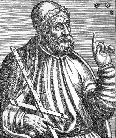
Claudius Ptolemy
Claudius Ptolemy (Latin Claudius Ptolemaeus; around 100, possibly in Ptolemais Hermeiou, Egypt - after 160, probably in Alexandria) was a Greek mathematician, geographer, astronomer, astrologer, music theorist and philosopher. He lived in Alexandria in the Roman province of Egypt. His three works on astronomy, geography and astrology in particular were regarded as standard scientific works and important collections of data in Europe until the early modern period. Ptolemy is the most important representative of the geocentric view of the world.
- Mela, Pomponius (author) Ptolemaios (Ptolemy, Ptolemäus) (other authors) AfricaCatalog No.: 21645
Northern Africa. "Africa" (title above the map) - "Lybia Interior" (title in map). Orig. woodcut from P. Mela's "De Orbis Situ Libri tres". Published by Henric Perti in Basel, 1564. 12,5:15,5 cm (5 x 6 1/4 inch.).
2 500,00 KčFor sale - Münster, Sebastian (author) Ptolemaios (Ptolemy, Ptolemäus) (other authors) Münster - The World- Typus Orbis a Ptol....Catalog No.: 22519
The World. "Typus Orbis a Ptol. Descriptus". Orig. woodcut, S. Münster after C. Ptolemy's map of the Ancient World. Orig. old coluring. Basel, H. Petri, 1540. With Latin title at the top and 12 classical windheads in the decorative region outside the map, each named....
20 000,00 KčFor sale - Münster, Sebastian (author) Ptolemaios (Ptolemy, Ptolemäus) (other authors) North Africa - Aphricae Tabula I,...Catalog No.: 00428
North Africa. "Aphricae Tabula I". Orig. woodblock from the first edition of S. Münster's Geographia. Published by Heinrch Petri in Basel, 1540. With latin title above the map, a cartouche and depiction of a ship. 25,5:33 cm (10 x 13 inch.).
9 000,00 KčFor sale - Münster, Sebastian (author) Ptolemaios (Ptolemy, Ptolemäus) (other authors) North Africa - Aphricae Tabula II,...Catalog No.: 00427
North Africa. "Aphricae Tabula II". Orig. woodblock from the first edition of S. Münster's Geographia. Published by Heinrch Petri in Basel, 1540. With latin title above the map, a cartouche and a depiction of the Apostle Paul's shipwreck near Malta. 25,5:33,5 cm (10 x 13 1/4 inch.).
10 000,00 KčFor sale - Münster, Sebastian (author) Ptolemaios (Ptolemy, Ptolemäus) (other authors) Northeast Africa - Tabula Aphricae III,...Catalog No.: 00426
Northeast Africa (Egypt). "Tabula Aphricae III". Orig. woodblock from the S. Münster's Geographia. Published by Heinrich Petri in Basel, 1542. With latin title above the map, 2 cartouches and a depiction of a sea monster devouring a sailor. 25,5:34 cm (10 x 13 1/2 inch.).
8 000,00 KčFor sale - Ruscelli, Girolamo (author) Ptolemaios (Ptolemy, Ptolemäus) (other authors) Tabula Africae IIIICatalog No.: 17166
North Africa. "Tabula Africae IIII". Orig. copper-engraving from G. Ruscelli's edition of Ptolemy's Geography. Published in Venice by G. Ziletti, 1562. With title above the map. 19:25 cm (7 1/2 x 10 inch.).
2 500,00 KčFor sale - Ruscelli, Girolamo (author) Ptolemaios (Ptolemy, Ptolemäus) (other authors) Tabula Aphricae ICatalog No.: 17208
Northwest Africa. "Tabula Aphricae I". Orig. copper-engraving from G. Ruscelli's edition of Ptolemy's Geography. Published in Venice by G. Ziletti, 1562. With title above the map. 18,5:25 cm (7 1/4 x 10 inch.).
2 500,00 KčFor sale - Ruscelli, Girolamo (author) Ptolemaios (Ptolemy, Ptolemäus) (other authors) Tabula Asiae IIIICatalog No.: 17220
Syria, Israel, Jordan and Cyprus. "Tabula Asiae IIII". Orig. copper-engraving from G. Ruscelli's edition of Ptolemy's Geography. Published in Venice by G. Ziletti, 1562. With title above the map. 19:25 cm (7 1/2 x 9 3/4 inch.).
6 000,00 KčFor sale - Ruscelli, Girolamo (author) Ptolemaios (Ptolemy, Ptolemäus) (other authors) Tabula Asiae IXCatalog No.: 17211
Iran, Afghanistan and Pakistan. "Tabula Asiae IX". Orig. copper-engraving from G. Ruscelli's edition of Ptolemy's Geography. Published in Venice by G. Ziletti, 1562. With title above the map. 18,5:24 cm (7 1/4 x 9 1/2 inch.).
2 500,00 KčFor sale - Ruscelli, Girolamo (author) Ptolemaios (Ptolemy, Ptolemäus) (other authors) Tabula Asiae VCatalog No.: 17217
Persia (Iran and Iraq). "Tabula Asiae V". Orig. copper-engraving from G. Ruscelli's edition of Ptolemy's Geography. Published in Venice by G. Ziletti, 1562. With title above the map. 19:25 cm (7 1/2 x 9 3/4 inch.).
2 500,00 KčFor sale - Ruscelli, Girolamo (author) Ptolemaios (Ptolemy, Ptolemäus) (other authors) Tabula Asiae VIIICatalog No.: 17256
India, China, Nepal. "Tabula Asiae VIII". Orig. copper-engraving from G. Ruscelli's edition of Ptolemy's Geography. Published in Venice by G. Ziletti, 1562. With title above the map. 18,5:24,5 cm (7 1/4 x 9 3/4 inch.).
3 000,00 KčFor sale - Mercator, Gerardus (author) Ptolemaios (Ptolemy, Ptolemäus) (other authors) Africae I. Tab:Catalog No.: 06126
Northwest Africa. "Africae I. Tab:". Orig. copperplate engraving, G. Mercator after Ptolemaus' map of the region. Published by G. von Kempen in Cologne, 1578. Original old colouring.
Sold - Mercator, Gerardus (author) Ptolemaios (Ptolemy, Ptolemäus) (other authors) Africae IIII. Tab:Catalog No.: 06138
Northern Africa."Africae IIII. Tab:". Orig. copper-engraving by G. Mercator after Ptolemaus' map of the region, published 1578. Original old colouring. With printed heading title and great ornamental cartouche 31:47 cm (12 1/4 x 18 1/2 inch.).
Sold - Ptolemaios (Ptolemy, Ptolemäus) Aphricae Tabvla ICatalog No.: 16530
Northwest Africa."Aphricae Tabula I". Orig. woodcut by S. Munster after C. Ptolemaeus' map of the region. Published in Basle by H. Petri, 1540. Orig. old colouring. With Lat. heading title, a cartouche with explanatory notes and a ship. 27:33 cm...
Sold - Ptolemaios (Ptolemy, Ptolemäus) Aphricae Tabvla IICatalog No.: 16533
North Africa."Aphricae Tabula II". Orig. woodcut, S. Munster after C. Ptolemaeus' map of the region. Published in Basle by H. Petri, 1540. Orig. old colouring. With Lat. heading title, a cartouche with explanatory notes and depiction of St....
Sold - Ptolemaios (Ptolemy, Ptolemäus) HispaniaCatalog No.: 05211
"Hispania". Orig. wood block from J. Honter (1498-1549) "Rudimentorum ...", published ca. 1550. 13:16 cm (5 x 6 1/4 inch.).
Sold - Ptolemaios (Ptolemy, Ptolemäus) PamphiliaCatalog No.: 08877
"Pamphilia". Orig. wood block from J. Honter (1498-1549) "Rudimentorum ...", published ca. 1550. 14,5:15,5 cm (5 3/4 x 6 1/4 inch.).
Sold - Ptolemaios (Ptolemy, Ptolemäus) Polonia et Vngaria, XV. Nova TabulaCatalog No.: 02940
"Polonia et Ungaria, XV. Nova Tabula". Original woodcut from lat. edition of C. Ptolemaeus' Geographia by S. Münster, first ed., 1540. 25,5:34,5 cm.
Sold - Ptolemaios (Ptolemy, Ptolemäus) Scythia EvropaeaCatalog No.: 05208
"Scythia Europaea". Orig. wood block from J. Honter (1498-1549) "Rudimentorum ...", published ca. 1550. 14:16 cm (5 1/2 x 6 1/4 inch.).
Sold - Porro, Girolamo (author) Ptolemaios (Ptolemy, Ptolemäus) (other authors) Slovenia, Croatia - Tabula Europae quinta,...Catalog No.: 02634
"Tabula Europae quinta". Copper-engraving by G. Porro according to C. Ptolemaeus' map of the region, published by G. Magini, 1597. With sea-creatures. 12:16,5 (4.7 x 6.5 inch.).
Sold - Ptolemaios (Ptolemy, Ptolemäus) Tabula Africae III.Catalog No.: 02610
Egypt."Tabula Africae III.". Copper-engraving by G. Porro after C. Ptolemaeus' map of the region, published by G. Magini, 1597. 13,6:17,5 cm (5.4 x 6.9 inch.).
Sold - Ptolemaios (Ptolemy, Ptolemäus) Tabula Africae. IIII.Catalog No.: 02607
Northern Africa."Tabula Africae. IIII.". Copper-engraving by G. Porro after C. Ptolemaeus' map of the region, published by G. Magini, 1597. 13,7:17,8 cm (5.4 x 7 inch.).
Sold - Ptolemaios (Ptolemy, Ptolemäus) Tabula Aphricae I.Catalog No.: 02616
Northern Africa."Tabula Aphricae I.". Copper-engraving by G. Porro according to C. Ptolemaeus' map of the region, published by G. Magini, 1597. With sea-creatures. 13,5:17,5 cm (5.3 x 6.9 inch.).
Sold - Ptolemaios (Ptolemy, Ptolemäus) Tabula Aphricae II.Catalog No.: 02613
Northern Africa."Tabula Aphricae II.". Copper-engraving by G. Porro after C. Ptolemaeus' map of the region, published by G. Magini, 1597. With sea-creatures. 13,6:17,5 cm (5.4x6.9 inch).
Sold - Ptolemaios (Ptolemy, Ptolemäus) Tabula Asiae I.Catalog No.: 02604
"Tabula Asiae I.". Copper-engraving by G. Porro according to C. Ptolemaeus' map of the region, published by G. Magini, 1597. 13,5:17,5 cm (5.3 x 6.9 inch.).
Sold - Ptolemaios (Ptolemy, Ptolemäus) Tabula Asiae IICatalog No.: 02781
"Tabula Asiae II". Copper-engraving by G. Porro according to C. Ptolemaeus' map of the region, published by G. Magini, 1597. 12,5:17 cm (5 x 6 3/4 inch.).
Sold - Ptolemaios (Ptolemy, Ptolemäus) Tabula Asiae IIIICatalog No.: 02649
"Tabula Asiae IIII". Copper-engraving by G. Porro after C. Ptolemaeus' map of the region, published by G. Magini, 1597. With sea-creatures. 12,5:17 cm.
Sold - Ptolemaios (Ptolemy, Ptolemäus) Tabula Asiae V.Catalog No.: 02787
"Tabula Asiae V.". Copper-engraving by G. Porro after C. Ptolemaeus' map of the region, published by G. Magini, 1597. 12,5:17 cm.
Sold - Ptolemaios (Ptolemy, Ptolemäus) Tabula Asiae VI.Catalog No.: 02601
"Tabula Asiae VI.". Copper-engraving by G. Porro after C. Ptolemaeus' map of the region, published by G. Magini, 1597. 13,5:17 cm (5.3 x 6.7 inch.).
Sold - Ptolemaios (Ptolemy, Ptolemäus) Tabula Asiae XCatalog No.: 02730
India."Tabula Asiae X". Woodcut from Ptolemy's "Geographia", published by S. Munster, 1540. Original old colouring. With 3 text - cartouches. 25:25 (35) cm, trapezial format.
Sold - Ptolemaios (Ptolemy, Ptolemäus) Tabula Asiae X.Catalog No.: 02643
India."Tabula Asiae X.". Copper-engraving by G. Porro according to C. Ptolemaeus' map of the region, published by G. Magini, 1597. 12,5:17 cm (5 x 6 3/4 inch.).
Sold - Ptolemaios (Ptolemy, Ptolemäus) Tabula Europae IX.Catalog No.: 02640
"Tabula Europae IX.". Copper-engraving by G. Porro according to C. Ptolemaeus' map of the region, published by G. Magini, 1597. 12,5:17 (4.9 x 6.7 inch.).
Sold - Ptolemaios (Ptolemy, Ptolemäus) Tabula Europae VI.Catalog No.: 02637
"Tabula Europae VI.". Copper-engraving by G. Porro according to C. Ptolemaeus' map of the region, published by G. Magini, 1597. With sea-creatures. 12,5:17 (4.9 x 6.7 inch.).
Sold - Ptolemaios (Ptolemy, Ptolemäus) Tabula Europae VIIICatalog No.: 02796
"Tabula Europae VIII". Copper-engraving by G. Porro according to C. Ptolemaeus' map of the region, published by G. Magini, 1597. 12,5:17 cm.
Sold - Magini, Giovanni Antonio (author) Ptolemaios (Ptolemy, Ptolemäus) (other authors) Tabvla Asiae IIICatalog No.: 02784
"Tabula Asiae III". Orig. copper-engraving from G. A. Magini's Geographiae Universae. Engraved by G. Porro. Published in Nuremberg by P. Keschedt, 1597. 12,5:17 cm (5 x 6 3/4 inch.).
Sold - Ptolemaios (Ptolemy, Ptolemäus) Tabvla Asiae IIIICatalog No.: 10602
"Tabula Asiae IIII". Orig. woodcut by S. Munster after C. Ptolemaeus' map of the region. Published by H. Petri in Basle, ca. 1540. Orig. old colouring. With Lat. heading title and 4 cartouches. 27:34,5 cm (10 3/4 x 13 1/2 inch.).
Sold - Magini, Giovanni Antonio (author) Ptolemaios (Ptolemy, Ptolemäus) (other authors) Tabvla Asiae IXCatalog No.: 02793
"Tabula Asiae IX". Orig. copper-engraving from G. A. Magini's Geographiae Universae. Engraved by G. Porro. Published in Nuremberg by P. Keschedt, 1597. 12,5:17 cm (5 x 6 3/4 inch.).
Sold - Ptolemaios (Ptolemy, Ptolemäus) Tabvla Asiae IXCatalog No.: 13026
Pakistan."Tabula Asiae IX". Orig. woodcut from the first edition of C. Ptolemaeus' Geographia by S. Munster. Published in Basle by H. Petri, 1540. Orig. old colouring. With Lat. heading title and a cartouche with the list of main cities of the...
Sold - Ptolemaios (Ptolemy, Ptolemäus) Tabvla Asiae VCatalog No.: 13029
"Tabula Asiae V". Orig. woodcut from the first edition of C. Ptolemaeus' Geographia by S. Munster. Published in Basle by H. Petri, 1540. Orig. old colouring. With Lat. heading title and 2 cartouches. 27:34,5 cm (10 3/4 x 13 1/2 inch.).
Sold - Ptolemaios (Ptolemy, Ptolemäus) Tabvla Asiae VICatalog No.: 10605
"Tabula Asiae VI". Orig. woodcut, S. Munster after C. Ptolemaeus' map of the region. Published in Basle by H. Petri, 1540. Orig. old colouring. With Lat. heading title, ornamental cartouche and a mermaid. 27:34,5 cm (10 3/4 x 13 1/2 inch.).
Sold - Ptolemaios (Ptolemy, Ptolemäus) Tabvla Asiae VICatalog No.: 10608
"Tabula Asiae VI". Orig. woodcut by S. Munster after C. Ptolemaeus' map of the region. Published in Basle by H. Petri, ca. 1540. With Lat. heading title, ornamental cartouche and a mermaid. 27:34,5 cm (10 3/4 x 13 1/2 inch.).
Sold - Ptolemaios (Ptolemy, Ptolemäus) Tabvla Asiae XIICatalog No.: 08013
"Tabula Asiae XII". Original wood-cut after C. Ptolemaeus' map of Sri Lanka (Ceylon) by Sebastian Munster, published 1540. With Latin heading title, large depiction of an elephant and ornamental cartouche. 27:34,5 cm (10 3/4 x 13 3/4 inch.).
Sold - Ptolemaios (Ptolemy, Ptolemäus) Tabvla Evropae IICatalog No.: 16536
"Tabula Europae II". Orig. woodcut, S. Munster after C. Ptolemaeus' map of the region. Published in Basle by H. Petri, 1540. Orig. old colouring. With Lat. heading title, 3 cartouches with explanatory notes and old handwritten notes on the left....
Sold - Ptolemaios (Ptolemy, Ptolemäus) Tabvla Evropae VCatalog No.: 16539
"Tabula Europae V". Orig. woodcut, S. Munster after C. Ptolemaeus' map of the region. Published in Basle by H. Petri, 1540. Orig. old colouring. With Lat. heading title, a cartouche with explanatory notes, a cherub on a sea-monster in "Mare...
Sold - Ptolemaios (Ptolemy, Ptolemäus) Tabvla Evropae VIICatalog No.: 17931
Malta, Sardinia and Sicily."Tabula Europae VII". Orig. woodcut, S. Munster after C. Ptolemaeus' map of the region. Published in Basle by H. Petri, 1540. Orig. old colouring. With Lat. heading title, 2 cartouches with explanatory notes and...
Sold - Ptolemaios (Ptolemy, Ptolemäus) Tabvla Evropae VIICatalog No.: 08016
"Tabula Europae VII". Original wood-cut after C. Ptolemaeus' map of the region by Sebastian Munster, published 1540. With Latin heading title, 2 decorative cartouches and depiction of a naval battle scene. 27,5:36 cm (10 3/4 x 14 1/4 inch.).
Sold - Ptolemaios (Ptolemy, Ptolemäus) Tabvla Evropae VIICatalog No.: 16542
"Tabula Europae VII". Orig. woodcut, S. Munster after C. Ptolemaeus' map of the region. Published in Basle by H. Petri, 1540. Orig. old colouring. With Lat. heading title, 2 cartouches with explanatory notes and depiction of a naval battle scene....
Sold - Ptolemaios (Ptolemy, Ptolemäus) Tabvla Evropae XCatalog No.: 16545
Greece. "Tabula Europae X". Orig. woodcut, S. Munster after C. Ptolemy's map of the region. Published in Basle by H. Petri, 1540. Orig. old colouring. With Lat. heading title and 3 cartouches with explanatory notes. 27:33,5 cm (10 3/4 x 13 1/4 inch.).
Sold - Ptolemaios (Ptolemy, Ptolemäus) Totius Africae tabula & descriptio...Catalog No.: 02727
Africa."Totius Africae tabula & descriptio universalis, etiam ultra Ptolemaei limites extensa". Original wood-cut after C. Ptolemaeus' map of Africa published by Sebastian Munster, ca. 1550. With Latin heading title, ornamental cartouche and rich...
Sold


