Keine Artikel
Kategorien
- Alte Landkarten und Stadtansichten
- Afrika
- Amerika
- Amerika (Kontinent)
- Antillen
- Argentinien
- Bermudainseln
- Brasilien
- Chile
- Florida
- Guyana
- Hawaiiinseln
- Honduras
- Kalifornien
- Kanada
- Kolumbien
- Louisiana
- Magellanstraße
- Mexico
- Mittelamerika und Antillen
- Neuengland
- New York
- Nordamerika
- Nordkaroline
- Panama
- Paraguay
- Pennsylvania
- Peru
- Südamerika
- Uruguay
- Venezuela
- Vereinigte Staaten (USA)
- Alabama
- Arkansas
- Boston
- Connecticut
- Florida
- Georgia
- Illinois
- Iowa
- Kentucky
- Louisiana
- Maine
- Maryland und Delaware
- Massachusetts und Rhode Island
- Michigan
- Mississippi
- Missouri
- New Hampshire und Vermont
- New Jersey
- New York
- Ohio
- Ostküste von USA
- Pennsylvania
- Philadelphia
- Rhode Island
- South Carolina
- Tennessee
- Texas
- Virginia
- Wisconsin
- Virginia
- Asien und Australien
- Asien (Kontinent)
- Australien
- Burma
- China
- Französisch-Polynesien
- Golf von Bengalen
- Indien
- Indien, China, Nepal
- Indischer Ozean
- Indonesien
- Israel / Palästina
- Japan
- Kaspische Meer
- Korea
- Malaysien
- Mikronesien
- Naher Osten
- Neuseeland
- Nordostasien
- Ostasien
- Pakistan
- Philippinnen
- Polynesien
- Sri Lanka (Ceylon)
- Südostasien
- Südwestasien
- Türkei
- Atlases
- Europa
- Belgien, Niederlande, Luxemburg
- Alkmaar
- Amsterdam
- Antwerpen
- Arnhem
- Belgien und Luxemburg
- Bergen op Zoom
- Blokzijl
- Bommenede
- Brabant
- Breda
- Brielle
- Brugge
- Brüssel
- Charleroi
- Delft
- Den Haag
- Dinant
- Doornik
- Dordrecht
- Drenthe
- Drenthe und Overijseel
- Elburg
- Flandern
- Fort Rammekens
- Friesland
- Friesland und Groningen
- Geertruidenberg
- Gelderland
- Geraardsbergen
- Grave
- Groningen
- Haarlem
- Hainaut
- Hannut
- Harderwijk
- Harlingen
- Holland
- Hulst
- Huy
- Kortryk
- Leeuwarden
- Leiden
- Lier
- Limbourg
- Limburg
- Löwen
- Lüttich
- Luxemburg
- Luxemburg (Stadt)
- Maastricht
- Mechelen
- Menin
- Middelburg
- Mons
- Namur
- Niederlande
- Niederlande und Belgien
- Nijmegen
- Ostende
- Overijssel
- Rotterdam
- Ruremonde
- s-Hertogenbosch
- Spa
- Stavoren
- Steenwijk
- Tiel
- Utrecht
- Veere
- Veurne
- Vlissingen
- Ypern
- Zaltbommel
- Zeeland
- Zieriksee
- Zierikzee
- Zutphen
- Zwolle
- Zype
- Böhmen, Mähren, Schlesien und Lausitz
- Adršpach
- Andělská Hora (hrad)
- Arnau
- Aussig
- Bad Liebwerda
- Bechyňsko
- Beraun
- Berounsko
- Berounsko a Plzeňsko
- Bílina
- Blansko
- Blatná
- Böhmen
- Böhmen, Mähren und Schlesien
- Bollechowitz
- Bömisch Aicha
- Borotín
- Bösig
- Boskovice
- Bouzov
- Brandýs nad Labem
- Branná (okr. Šumperk)
- Břeclav
- Březnice
- Brněnsko
- Brněnsko a Uherskohardišťsko
- Brodce (okr. Mladá Boleslav)
- Broumov
- Brtnice
- Brünn
- Budeč (hradiště)
- Budweis
- Bürglitz
- Buštěhrad
- Buzice (tvrz)
- Čáslav
- Čáslavsko
- Čelákovice
- Česká Lípa
- České Švýcarsko
- Český Brod
- Český Krumlov
- Český Šternberk
- Cheb
- Chebsko a Žatecko
- Chlum (okr. Kutná Hora)
- Chlum Svaté Máří
- Chlumec nad Cidlinou
- Chodová Planá
- Chomutov
- Choustníkovo Hradiště (zřícenina hradu)
- Chrudim
- Chrudimsko
- Chrudimsko, Čáslavsko, Kouřimsko
- Děčín
- Dívčí Hrad
- Doksany (okr. Litoměřice)
- Dolní Olešnice - Nové Zámky
- Dolní Životice (okr. Opava)
- Doupov
- Dubí
- Duchcov
- Dvojhradí (Mstišov)
- Dvůr Králové nad Labem
- Eger - und Elbogenland
- Egerberg
- Egerberk (Klášterec nad Ohří)
- Felixburg (Klášterec nad Ohří)
- Františkovy Lázně
- Frauenberg in Böhmen
- Frenštát pod Radhošťem
- Friedrichsthal
- Frýdlant
- Graupen
- Habrovany
- Hartenberg (Hřebeny, okr. Sokolov)
- Hassenstein
- Hauenštejn (Horní hrad, okr. Karlovy Vary)
- Házmburk
- Helfštýn
- Herrnskretschen
- Hlavačov (Hlaváčov, Rakovník)
- Hohenelbe
- Hořice (v Podkrkonoší)
- Hradec Králové
- Hranice na Moravě
- Hrubá Skála
- Hukvaldy
- Jáchymov
- Jankov
- Jánský Vrch
- Jánský Vrch (Javorník)
- Jaromirsch
- Jenstein
- Jeseník
- Jestřebí
- Jezeří
- Jičín
- Jihlava
- Jižní Čechy
- Johannesbad
- Kaceřov (Plzeň-sever)
- Kadaň
- Kamaick
- Karlsbad
- Karlstein
- Kasejovice - Řesanice
- Klabava (Ejpovice, okr. Rokycany)
- Kladno
- Kladruby
- Klatovy
- Kokořín
- Kolín
- Kondrac
- Konojedy (u Litoměřic)
- Konopiště
- Kopidlno (okr. Jičín)
- Kost
- Kostelec nad Labem
- Kostenblatt
- Kouřimsko
- Krakovec
- Králíky
- Královéhradecko
- Krásný Dvůr (okr. Louny)
- Krašov (hrad)
- Kratochvíle (zámek)
- Křečov (okr. Louny)
- Křepenice
- Krkonoše
- Krnov
- Kroměříž
- Krušné hory
- Kuks
- Kumburk
- Kunětická Hora
- Kunžvart (Šumava)
- Kuttenberg
- Kynšperk nad Ohří
- Kynžvart (zámek)
- Kyselka
- Kyšperk
- Lanšperk
- Laun
- Ledeč nad Sázavou
- Lednice
- Libá (okr. Cheb)
- Libějovice
- Liberec
- Liběšice
- Liblín (okr. Rokycany)
- Libochovany
- Libochovice
- Libštejn
- Lina (Vroutek, okr. Louny)
- Lipnice nad Sázavou
- Litoměřice
- Litoměřicko
- Litomyšl
- Littitz
- Lobositz
- Loket
- Luhačovice
- Lužice
- Lysá nad Labem
- Mähren
- Marienbad
- Melnik
- Mikulov
- Milčany
- Milešov (Velemín)
- Milešovka
- Miletín
- Milíčeves (okr. Jičín)
- Mladá Boleslav
- Mladoboleslavsko
- Mladoboleslavsko a Litoměřicko
- Mnichovo Hradiště
- Most
- Mšec
- Mühlhausen an der Moldau
- Mürau
- Náchod
- Napajedla
- Návarov
- Nepomuk
- Neuhaus
- Nimburg
- Nové Hrady (okr. Ústí nad Orlicí)
- Nový Bor
- Okoř
- Olmütz
- Olomoucko
- Ondrášov (Moravský Beroun)
- Opava
- Orlík nad Vltavou
- Osek
- Ostrov nad Ohří
- Pardubice
- Patzau
- Pavlov
- Pecka (hrad)
- Pernstein
- Petrohrad (Petršpurk, okr. Louny)
- Písek
- Plaňany
- Plasy
- Plzeň
- Plzeňsko
- Podiebrad
- Polná
- Prachatice
- Prácheňsko
- Prag
- Praha - Cheb
- Praha a okolí
- Prerau
- Přerovsko
- Pressnitz
- Proboštov
- Proseč u Pošné (okr. Pelhřimov)
- Protivín
- Przelautsch
- Pullitz
- Raabstein
- Rabí
- Račice (Vyškov)
- Radim (okr. Kolín)
- Rájec nad Svitavou
- Rajhrad
- Rakovnicko
- Rakovník
- Ronov (okr. Česká Lípa)
- Ronov nad Sázavou
- Rosstein
- Roudnice nad Labem
- Rožmberk nad Vltavou
- Rožnov pod Radhoštěm
- Rudolfov (České Budějovice)
- Rychmburk
- Rychnov nad Kněžnou
- Rýzmburk (hrad)
- Rzeczkowitz
- Schellenberg
- Schlan
- Schreckenstein
- Schwamberg
- Sedlec
- Severní Čechy
- Skuteč
- Slavkov u Brna
- Sloup (hrad)
- Smečna
- Smidary (okr. Hradec Králové)
- Smirschitz
- Sovinec (hrad)
- Šternberk (Ledce)
- Strakonice
- Štramberk
- Šumava
- Šumburk (Šumná)
- Šumperk
- Svatý Jan pod Skalou
- Svojanov (hrad)
- Svojšice
- Tábor
- Táborsko a Českobudějovicko
- Tachov
- Telenice - Varvažov
- Teplá
- Teplice
- Theresienstadt
- Toužetín
- Třebel
- Třeboň
- Trhanov (okr. Domažlice)
- Trosky
- Tuchoraz
- Týn nad Vltavou
- Týnec nad Labem
- Uherské Hradiště
- Újezdec (hrad)
- Uničov
- Úvaly
- Valdštejn
- Valkeřice
- Valtice
- Vartenberk - Stráž pod Ralskem (okr. Česká Lípa)
- Velehrad
- Velhartice
- Velké Meziříčí
- Velké Žernoseky
- Veveří
- Vinec
- Višňová (okr. Liberec)
- Vlastislav
- Vlkava
- Vltava
- Vrabinec
- Vřeskovice
- Východní a Severovýchodní Čechy
- Vysoké Mýto
- Vyšší Brod
- Wegstädtl
- Winterberg
- Žacléř
- Zahájí
- Zákupy
- Žampach (zámek)
- Zámrsk
- Západní Čechy
- Žatec
- Žatecko
- Žebrák a Točník
- Želiv
- Žireč
- Žleb
- Zlenice (Hláska)
- Znojemsko a Jihlavsko
- Znojmo
- Zornstein
- Zvíkov
- Zvířetice
- Deutschland
- Donau
- Europa (Kontinent)
- Frankreich
- Albi
- Anjou
- Arras
- Artois
- Auvergne
- Avignon
- Bar-le-Duc
- Beauce
- Beauvais
- Berry
- Blois
- Bordeaux
- Bourbonnais
- Bourbourg
- Bresse
- Brie
- Burgund-Freigrafschaft
- Calais
- Cambrai
- Cassel
- Champagne
- Château de Lichtenberg
- Chaumont
- Compiegne und Noyon
- Dauphiné
- Département Tarn
- Dombes
- Douai
- Dünkirchen
- Elsass
- Fontainebleau
- Gascogne
- Gâstinais and Senonais
- Gravelines
- Hauts-de-France
- Hondschoote
- Ile de France
- Iles de Lérins
- Korsika
- La Bassée - Hesdin
- La Rochelle
- Languedoc
- Lille
- Limoges
- Lothringen
- Lyon
- Maine
- Marseille
- Metz
- Montmélian
- Mülhausen
- Nancy
- Nevers
- Nice
- Normandie
- Orange
- Paris
- Perche
- Perpignan
- Picardie
- Poitou
- Provence
- Quercy
- Re und Oleron
- Reims - Rethel
- Rethel
- Saint-Germain-en-Laye
- Saint-Omer
- Saintonge und Aunis
- Sarlat
- Savoyen
- Savoyen und Osten Burgund (Franche - Comte)
- Strassburg
- Südfrankreich
- Südostfrankreich
- Thérouanne
- Touraine
- Valenciennes
- Vexin
- Westfrankreich
- Wissembourg
- Griechenland, Mittelmeer
- Grossbritannien und Irland
- Bedford und Buckinghamshire
- Berkshire und Hampshire
- Cambridgeshire
- Cheshire
- Cornwall
- Cumberland
- Denbigh und Flint
- Derbyshire
- Devon
- Dorset
- Durham (Grafschaft)
- England
- Essex
- Exeter
- Gloucestershire
- Großbritannien und Irland
- Hampshire
- Herefordshire
- Hertfordshire
- Hertfordshire and Middlesex
- Holy Island und Farne Island
- Huntingdonshire
- Irland
- Isle of Man
- Isle of Wight
- Kent
- Lancashire
- Leicestershire
- Lincolnshire
- London
- Middlesex
- Nordengland
- Nordostengland
- Nordwestengland
- Norfolk
- Northampton
- Northumberland
- Nottinghamshire
- Orkneys und Shetland
- Oxfordshire
- Portsmouth
- Rutland
- Schottland
- Shropshire
- Shropshire und Staffordshire
- Somerset
- Staffordshire
- Südostengland
- Südwestengland
- Surrey
- Sussex
- Wales
- Westmorland
- Wiltshire
- Worcestershire und Warwickshire
- Yorkshire
- Italien
- Abruzzen
- Acquapendente
- Ancona
- Apulien (Puglia)
- Arcevia
- Assisi
- Bari und Basilikata
- Belluno und Feltre
- Bergamo
- Bologna
- Bracciano
- Brescia
- Brescia und Crema
- Cadore
- Cagliari
- Caiazzo
- Camerino
- Capitanata
- Carmagnola
- Catania
- Civitavecchia
- Crema
- Cremona
- Cuneo
- Elba
- Emilia Romagna
- Faenza
- Fano
- Ferrara
- Florenz
- Fondi
- Friaul
- Gaeta
- Gallipoli
- Genua
- Ischia
- Italien
- Kalabrien
- Kampanien
- Lago di Como
- Lago Maggiore
- Lazio
- Lerici
- Ligurien (Italienische Riviera)
- Livorno
- Lombardei
- Loreto
- Lucca
- Mailand
- Mantua
- Mantua
- Marche (Ancona)
- Meran
- Messina
- Mirandola
- Mittelitalien
- Modena
- Molise
- Monferrato
- Neapel
- Netuno
- Nocera Umbra
- Norditalien
- Orvieto
- Orvieto und Loreto
- Otranto
- Padua
- Palermo
- Parma
- Parma und Piacenza
- Pavia
- Perugia
- Pesaro
- Piacenza
- Piemont
- Pinerolo
- Piombino
- Pisa
- Po
- Pozzuoli
- Puglia und Calabria
- Ravenna
- Reggio di Calabria
- Reggio Emilia
- Rimini
- Rom
- Romagna
- Rovereto
- Rovigo
- San Marino
- Sardinien
- Siena
- Sizilien
- Sizilien und Malta
- Sizilien und Sardinien
- Spoleto
- Süditalien
- Sulmona
- Taranto
- Terracina
- Tirol
- Tivoli
- Tortona
- Toskana
- Trapani
- Trentino
- Trentino-Alto Adige / Südtirol
- Treviso
- Tricarico
- Triest
- Turin
- Udine
- Umbria
- Urbino
- Velletri
- Venedig
- Vercelli
- Verona
- Vicenza
- Viterbo
- Labe
- Mitteleuropa
- Mittelmeer
- Monaco
- Nordeuropa
- Österreich
- Ostsee
- Polen, Schlesien, Rußland, Blatikum
- Rhein
- Schweiz
- Skandinavien und Island
- Spanien und Portugal
- Andalusien
- Andalusien und Granada
- Aragonien
- Azoren
- Balearen
- Barcelona
- Barcelona und Ecija
- Burgos
- Cadiz
- Cordoba
- Extremadura
- Galizien
- Gibraltar
- Granada
- Kanarische Inseln
- Kastilien
- Katalanien
- Leon und Asturien
- Lissabon
- Madeira
- Madrid
- Navarra
- Nordostspanien
- Nordspanien
- Nordwestlichen Spanien
- Portugal
- Roses
- Sevilla
- Spanien
- Toledo und Valladolid
- Valencia
- Südost- und Osteuropa, Balkan
- Belgien, Niederlande, Luxemburg
- Inseln (Sonderkatalog)
- Welt, Ozeane, Pole und Sternbildkarten
- Bücher
- 17., 18. a 19. století - Bohemika, Moravika, České národní obrození
- 17., 18. und 19. Jhdt. - Literatur, Illustrierte etc. - Ausland
- 20. Jhdt. - Literatur, Poesie, Pressendrucke etc. - Ausland
- 20. Jhdt. - Literatur, Poesie, Pressendrucke, Buchbinderei etc. - Tschechisch
- Alte Drucke (15. - 16. Jahrhundert)
- Bildende Kunst und Architektur
- Geschichte und Recht
- Kinder- und Jugendbücher
- Kulturgeschichte, Varia
- Natur und Naturwissenschaften
- Philosophie, Theologie, Pädagogik, Ökonomie, Soziologie
- Topographie, Reisen und Geographie
- Graphik und Zeichnungen
- Alte Graphik, Zeichnungen und dekorative
- Alte Meistergrafik
- Devotionalien und kleine Gebrauchsgrafiken (Andachtsbilder, Glückwünsche usw.)
- Europeische moderne Kunst (Graphik, Ex-libris, Zeichnungen)
- Japanische Holzschnitte
- Tschechische Kunst des 20. Jhdt. (Graphik, Ex-libris, Zeichnungen)
- Balcar, Jiří (1929-1968)
- Bílek, František (1872-1941)
- Bím, Tomáš (1946)
- Born, Adolf (1930)
- Bouda, Cyril (1901-1984)
- Chadima, Jiří (nar. 1923)
- Demel, Karel
- Fischerová-Kvěchová, Marie (1892-1984)
- Gross, František (1909-1985)
- Hodek, Josef mladší (1888-1973)
- Holler, Josef (1903-1982)
- Hudeček, František (1909-1990)
- Jiřincová, Ludmila (1912-1994)
- Kobliha, František (1877-1962)
- Konůpek, Jan (1883-1950)
- Lada, Josef (1887-1957)
- Lhoták, Kamil (1912-1990)
- Malich, Karel (1924-2019)
- Mrkvicka, Otakar (1898-1957)
- Mucha, Alfons
- Obrátil, Karel Jaroslav
- Orlik, Emil (1870-1932)
- Preissig, Vojtěch
- Rambousek, Jan (1895-1976)
- Sekora, Ondřej (1899-1967)
- Seydl, Zdenek (1916-1978)
- Šimon, Tavík František (1877-1942)
- Sladek, Jan (1906-1982)
- Stretti, Viktor (1878-1957)
- Stretti-Zamponi, Jaromír (1882-1959)
- Švabinský, Max (1873-1962)
- Tichý, František (1896-1961)
- Tomanová, Emilie (1933-1994)
- Trnka, Jiří (1912-1969)
- Uprka, Joža (1861-1940)
- Váchal, Josef (1884-1969)
- Vik, Karel (1883-1969)
- Vondrouš, Jan Charles (1884-1970)
- Wenig, Josef (1885-1939)
- Zrzavý, Jan (1890-1977)
- Varia
Liste der Werke von Autor: Ptolemaios (Ptolemy, Ptolemäus)
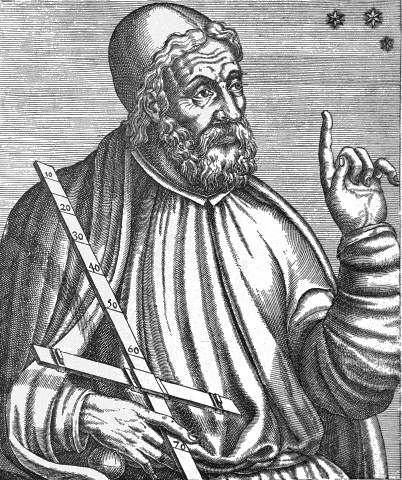
Claudius Ptolemäus
Claudius Ptolemäus (lateinisch Claudius Ptolemaeus; um 100, möglicherweise in Ptolemais Hermeiou, Ägypten - nach 160, vermutlich in Alexandria) war ein griechischer Mathematiker, Geograph, Astronom, Astrologe, Musiktheoretiker und Philosoph. Er lebte in Alexandria in der Römischen Provinz Ägypten. Insbesondere seine drei Werke zur Astronomie, Geografie und Astrologie galten in Europa bis zur frühen Neuzeit als wissenschaftliche Standardwerke und wichtige Datensammlungen. Ptolemäus ist der bedeutendste Vertreter des geozentrischen Weltbildes.
- Mela, Pomponius (Autor) Ptolemaios (Ptolemy, Ptolemäus) (Andere Autoren) AfricaBestell-Nr .: 21645
Nordafrika. "Africa" (title above the map) - "Lybia Interior" (title in map). Orig. woodcut from P. Mela's "De Orbis Situ Libri tres". Published by Henric Perti in Basel, 1564. 12,5:15,5 cm.
2 500,00 KčZu verkaufen - Münster, Sebastian (Autor) Ptolemaios (Ptolemy, Ptolemäus) (Andere Autoren) Münster - Die Wel - Typus Orbis a Ptol....Bestell-Nr .: 22519
Die Welt. "Typus Orbis a Ptol. Descriptus". Orig. woodcut, S. Münster after C. Ptolemy's map of the Ancient World. Orig. old coluring. Basel, H. Petri, 1540. With Latin title at the top and 12 classical windheads in the decorative region outside the map, each named....
20 000,00 KčZu verkaufen - Münster, Sebastian (Autor) Ptolemaios (Ptolemy, Ptolemäus) (Andere Autoren) Nordafrika - Aphricae Tabula I,...Bestell-Nr .: 00428
Nordafrika. "Aphricae Tabula I". Orig. woodblock from the first edition of S. Münster's Geographia. Published by Heinrch Petri in Basel, 1540. With latin title above the map, a cartouche and depiction of a ship. 25,5:33 cm.
9 000,00 KčZu verkaufen - Münster, Sebastian (Autor) Ptolemaios (Ptolemy, Ptolemäus) (Andere Autoren) Nordafrika - Aphricae Tabula II,...Bestell-Nr .: 00427
Nordafrika. "Aphricae Tabula II". Orig. woodblock from the first edition of S. Münster's Geographia. Published by Heinrch Petri in Basel, 1540. With latin title above the map, a cartouche and a depiction of the Apostle Paul's shipwreck near Malta. 25,5:33,5 cm.
10 000,00 KčZu verkaufen - Münster, Sebastian (Autor) Ptolemaios (Ptolemy, Ptolemäus) (Andere Autoren) Nordostafrika - Tabula Aphricae III,...Bestell-Nr .: 00426
Nordostafrika (Ägypten). "Tabula Aphricae III". Orig. woodblock from the S. Münster's Geographia. Published by Heinrich Petri in Basel, 1542. With latin title above the map, 2 cartouches and a depiction of a sea monster devouring a sailor. 25,5:34 cm.
8 000,00 KčZu verkaufen - Ruscelli, Girolamo (Autor) Ptolemaios (Ptolemy, Ptolemäus) (Andere Autoren) Tabula Africae IIIIBestell-Nr .: 17166
Nordafrika. "Tabula Africae IIII". Orig. copper-engraving from G. Ruscelli's edition of Ptolemy's Geography. Published in Venice by G. Ziletti, 1562. With title above the map. 19:25 cm.
2 500,00 KčZu verkaufen - Ruscelli, Girolamo (Autor) Ptolemaios (Ptolemy, Ptolemäus) (Andere Autoren) Tabula Aphricae IBestell-Nr .: 17208
Nordwestafrika. "Tabula Aphricae I". Orig. copper-engraving from G. Ruscelli's edition of Ptolemy's Geography. Published in Venice by G. Ziletti, 1562. With title above the map. 18,5:25 cm.
2 500,00 KčZu verkaufen - Ruscelli, Girolamo (Autor) Ptolemaios (Ptolemy, Ptolemäus) (Andere Autoren) Tabula Asiae IIIIBestell-Nr .: 17220
Syrien, Israel, Jordanien und Zypern. "Tabula Asiae IIII". Orig. copper-engraving from G. Ruscelli's edition of Ptolemy's Geography. Published in Venice by G. Ziletti, 1562. With title above the map. 19:25 cm.
6 000,00 KčZu verkaufen - Ruscelli, Girolamo (Autor) Ptolemaios (Ptolemy, Ptolemäus) (Andere Autoren) Tabula Asiae IXBestell-Nr .: 17211
Iran, Afghanistan und Pakistan. "Tabula Asiae IX". Orig. copper-engraving from G. Ruscelli's edition of Ptolemy's Geography. Published in Venice by G. Ziletti, 1562. With title above the map. 18,5:24 cm.
2 500,00 KčZu verkaufen - Ruscelli, Girolamo (Autor) Ptolemaios (Ptolemy, Ptolemäus) (Andere Autoren) Tabula Asiae VBestell-Nr .: 17217
Persien (Iran und Irak). "Tabula Asiae V". Orig. copper-engraving from G. Ruscelli's edition of Ptolemy's Geography. Published in Venice by G. Ziletti, 1562. With title above the map. 19:25 cm.
2 500,00 KčZu verkaufen - Ruscelli, Girolamo (Autor) Ptolemaios (Ptolemy, Ptolemäus) (Andere Autoren) Tabula Asiae VIIIBestell-Nr .: 17256
Indien, China, Nepal. "Tabula Asiae VIII". Orig. copper-engraving from G. Ruscelli's edition of Ptolemy's Geography. Published in Venice by G. Ziletti, 1562. With title above the map. 18,5:24,5 cm.
3 000,00 KčZu verkaufen - Mercator, Gerardus (Autor) Ptolemaios (Ptolemy, Ptolemäus) (Andere Autoren) Africae I. Tab:Bestell-Nr .: 06126
Nordwestafrika. "Africae I. Tab:". Orig. copperplate engraving, G. Mercator after Ptolemaus' map of the region. Published by G. von Kempen in Cologne, 1578. Original old colouring. 32,5:46,5 cm.
Verkauft - Mercator, Gerardus (Autor) Ptolemaios (Ptolemy, Ptolemäus) (Andere Autoren) Africae IIII. Tab:Bestell-Nr .: 06138
Nordafrika."Africae IIII. Tab:". Orig. copper-engraving by G. Mercator after Ptolemaus' map of the region, published 1578. Original old colouring. With printed heading title and great ornamental cartouche 31:47 cm.
Verkauft - Ptolemaios (Ptolemy, Ptolemäus) Aphricae Tabvla IBestell-Nr .: 16530
Northwest Africa."Aphricae Tabula I". Orig. woodcut by S. Munster after C. Ptolemaeus' map of the region. Published in Basle by H. Petri, 1540. Orig. old colouring. With Lat. heading title, a cartouche with explanatory notes and a ship. 27:33 cm.
Verkauft - Ptolemaios (Ptolemy, Ptolemäus) Aphricae Tabvla IIBestell-Nr .: 16533
North Africa."Aphricae Tabula II". Orig. woodcut, S. Munster after C. Ptolemaeus' map of the region. Published in Basle by H. Petri, 1540. Orig. old colouring. With Lat. heading title, a cartouche with explanatory notes and depiction of St....
Verkauft - Ptolemaios (Ptolemy, Ptolemäus) HispaniaBestell-Nr .: 05211
"Hispania". Orig. wood block from J. Honter (1498-1549) "Rudimentorum ...", published ca. 1550. 13:16 cm.
Verkauft - Ptolemaios (Ptolemy, Ptolemäus) PamphiliaBestell-Nr .: 08877
"Pamphilia". Orig. wood block from J. Honter (1498-1549) "Rudimentorum ...", published ca. 1550. 14,5:15,5 cm.
Verkauft - Ptolemaios (Ptolemy, Ptolemäus) Polonia et Vngaria, XV. Nova TabulaBestell-Nr .: 02940
"Polonia et Ungaria, XV. Nova Tabula". Holzschnittkarte (aus C. Ptolemaeus Geographia von S. Münster, EA, 1540). Mit lat. Kopftitel. 25,5:34,5 cm.
Verkauft - Ptolemaios (Ptolemy, Ptolemäus) Scythia EvropaeaBestell-Nr .: 05208
"Scythia Europaea". Orig. wood block from J. Honter (1498-1549) "Rudimentorum ...", published ca. 1550. 14:16 cm.
Verkauft - Porro, Girolamo (Autor) Ptolemaios (Ptolemy, Ptolemäus) (Andere Autoren) Slowenien, Croatien - Tabula Europae...Bestell-Nr .: 02634
"Tabula Europae quinta". Copper-engraving by G. Porro according to C. Ptolemaeus' map of the region, published by G. Magini, 1597. With sea-creatures. 12:16,5 (4.7 x 6.5 inch.).
Verkauft - Ptolemaios (Ptolemy, Ptolemäus) Tabula Africae III.Bestell-Nr .: 02610
Ägypten."Tabula Africae III.". Copper-engraving by G. Porro after C. Ptolemaeus' map of the region, published by G. Magini, 1597. 13,6:17,5 cm (5.4 x 6.9 inch.).
Verkauft - Ptolemaios (Ptolemy, Ptolemäus) Tabula Africae. IIII.Bestell-Nr .: 02607
Nordafrika."Tabula Africae. IIII.". Copper-engraving by G. Porro after C. Ptolemaeus' map of the region, published by G. Magini, 1597. 13,7:17,8 cm (5.4 x 7 inch.).
Verkauft - Ptolemaios (Ptolemy, Ptolemäus) Tabula Aphricae I.Bestell-Nr .: 02616
Nordafrika."Tabula Aphricae I.". Copper-engraving by G. Porro according to C. Ptolemaeus' map of the region, published by G. Magini, 1597. With sea-creatures. 13,5:17,5 cm (5.3 x 6.9 inch.).
Verkauft - Ptolemaios (Ptolemy, Ptolemäus) Tabula Aphricae II.Bestell-Nr .: 02613
Nordafrika."Tabula Aphricae II.". Copper-engraving by G. Porro after C. Ptolemaeus' map of the region, published by G. Magini, 1597. With sea-creatures. 13,6:17,5 cm (5.4x6.9 inch).
Verkauft - Ptolemaios (Ptolemy, Ptolemäus) Tabula Asiae I.Bestell-Nr .: 02604
"Tabula Asiae I.". Copper-engraving by G. Porro according to C. Ptolemaeus' map of the region, published by G. Magini, 1597. 13,5:17,5 cm (5.3 x 6.9 inch.).
Verkauft - Ptolemaios (Ptolemy, Ptolemäus) Tabula Asiae IIBestell-Nr .: 02781
"Tabula Asiae II". Copper-engraving by G. Porro according to C. Ptolemaeus' map of the region, published by G. Magini, 1597. 12,5:17 cm.
Verkauft - Ptolemaios (Ptolemy, Ptolemäus) Tabula Asiae IIIIBestell-Nr .: 02649
"Tabula Asiae IIII". Copper-engraving by G. Porro after C. Ptolemaeus' map of the region, published by G. Magini, 1597. With sea-creatures. 12,5:17 cm.
Verkauft - Ptolemaios (Ptolemy, Ptolemäus) Tabula Asiae V.Bestell-Nr .: 02787
"Tabula Asiae V.". Copper-engraving by G. Porro after C. Ptolemaeus' map of the region, published by G. Magini, 1597. 12,5:17 cm.
Verkauft - Ptolemaios (Ptolemy, Ptolemäus) Tabula Asiae VI.Bestell-Nr .: 02601
"Tabula Asiae VI.". Copper-engraving by G. Porro after C. Ptolemaeus' map of the region, published by G. Magini, 1597. 13,5:17 cm (5.3 x 6.7 inch.).
Verkauft - Ptolemaios (Ptolemy, Ptolemäus) Tabula Asiae XBestell-Nr .: 02730
Indien."Tabula Asiae X". Altkol. Holzschn. - Karte aus Ptolemäus "Geographia" bei S. Münster, 1540. Mit 3 Textkartuschen. 25:25 (35) cm, Trapezformat.
Verkauft - Ptolemaios (Ptolemy, Ptolemäus) Tabula Asiae X.Bestell-Nr .: 02643
Indien."Tabula Asiae X.". Copper-engraving by G. Porro according to C. Ptolemaeus' map of the region, published by G. Magini, 1597. 12,5:17 cm.
Verkauft - Ptolemaios (Ptolemy, Ptolemäus) Tabula Europae IX.Bestell-Nr .: 02640
"Tabula Europae IX.". Copper-engraving by G. Porro according to C. Ptolemaeus' map of the region, published by G. Magini, 1597. 12,5:17 (4.9 x 6.7 inch.).
Verkauft - Ptolemaios (Ptolemy, Ptolemäus) Tabula Europae VI.Bestell-Nr .: 02637
"Tabula Europae VI.". Copper-engraving by G. Porro according to C. Ptolemaeus' map of the region, published by G. Magini, 1597. With sea-creatures. 12,5:17 (4.9 x 6.7 inch.).
Verkauft - Ptolemaios (Ptolemy, Ptolemäus) Tabula Europae VIIIBestell-Nr .: 02796
"Tabula Europae VIII". Copper-engraving by G. Porro according to C. Ptolemaeus' map of the region, published by G. Magini, 1597. 12,5:17 cm.
Verkauft - Magini, Giovanni Antonio (Autor) Ptolemaios (Ptolemy, Ptolemäus) (Andere Autoren) Tabvla Asiae IIIBestell-Nr .: 02784
"Tabula Asiae III". Orig. copper-engraving from G. A. Magini's Geographiae Universae. Engraved by G. Porro. Published in Nuremberg by P. Keschedt, 1597. 12,5:17 cm.
Verkauft - Ptolemaios (Ptolemy, Ptolemäus) Tabvla Asiae IIIIBestell-Nr .: 10602
"Tabula Asiae IIII". Orig. woodcut by S. Munster after C. Ptolemaeus' map of the region. Published in Basle by H. Petri, ca. 1540. Orig. old colouring. With Lat. heading title and 4 cartouches. 27:34,5 cm.
Verkauft - Magini, Giovanni Antonio (Autor) Ptolemaios (Ptolemy, Ptolemäus) (Andere Autoren) Tabvla Asiae IXBestell-Nr .: 02793
"Tabula Asiae IX". Orig. copper-engraving from G. A. Magini's Geographiae Universae. Engraved by G. Porro. Published in Nuremberg by P. Keschedt, 1597. 12,5:17 cm.
Verkauft - Ptolemaios (Ptolemy, Ptolemäus) Tabvla Asiae IXBestell-Nr .: 13026
Pakistan."Tabula Asiae IX". Orig. woodcut from the first edition of C. Ptolemaeus' Geographia by S. Munster. Published in Basle by H. Petri, 1540. Orig. old colouring. With Lat. heading title and a cartouche with the list of main cities of the...
Verkauft - Ptolemaios (Ptolemy, Ptolemäus) Tabvla Asiae VBestell-Nr .: 13029
"Tabula Asiae V". Orig. woodcut from the first edition of C. Ptolemaeus' Geographia by S. Munster. Published in Basle by H. Petri, 1540. Orig. old colouring. With Lat. heading title and 2 cartouches. 27:34,5 cm.
Verkauft - Ptolemaios (Ptolemy, Ptolemäus) Tabvla Asiae VIBestell-Nr .: 10605
"Tabula Asiae VI". Orig. woodcut, S. Munster after C. Ptolemaeus' map of the region. Published in Basle by H. Petri, 1540. Orig. old colouring. With Lat. heading title, ornamental cartouche and a mermaid. 27:34,5 cm.
Verkauft - Ptolemaios (Ptolemy, Ptolemäus) Tabvla Asiae VIBestell-Nr .: 10608
"Tabula Asiae VI". Orig. woodcut by S. Munster after C. Ptolemaeus' map of the region. Published in Basle by H. Petri, ca. 1540. With Lat. heading title, ornamental cartouche and a mermaid. 27:34,5 cm.
Verkauft - Ptolemaios (Ptolemy, Ptolemäus) Tabvla Asiae XIIBestell-Nr .: 08013
"Tabula Asiae XII". Original wood-cut after C. Ptolemaeus' map of Sri Lanka (Ceylon) by Sebastian Munster, published 1540. With Latin heading title, large depiction of an elephant and ornamental cartouche. 27:34,5 cm.
Verkauft - Ptolemaios (Ptolemy, Ptolemäus) Tabvla Evropae IIBestell-Nr .: 16536
"Tabula Europae II". Orig. woodcut, S. Munster after C. Ptolemaeus' map of the region. Published in Basle by H. Petri, 1540. Orig. old colouring. With Lat. heading title, 3 cartouches with explanatory notes and old handwritten notes on the left....
Verkauft - Ptolemaios (Ptolemy, Ptolemäus) Tabvla Evropae VBestell-Nr .: 16539
"Tabula Europae V". Orig. woodcut, S. Munster after C. Ptolemaeus' map of the region. Published in Basle by H. Petri, 1540. Orig. old colouring. With Lat. heading title, a cartouche with explanatory notes, a cherub on a sea-monster in "Mare...
Verkauft - Ptolemaios (Ptolemy, Ptolemäus) Tabvla Evropae VIIBestell-Nr .: 17931
Malta, Sardinien und Sizilien."Tabula Europae VII". Orig. woodcut, S. Munster after C. Ptolemaeus' map of the region. Published in Basle by H. Petri, 1540. Orig. old colouring. With Lat. heading title, 2 cartouches with explanatory notes and...
Verkauft - Ptolemaios (Ptolemy, Ptolemäus) Tabvla Evropae VIIBestell-Nr .: 08016
"Tabula Europae VII". Original wood-cut after C. Ptolemaeus' map of the region by Sebastian Munster, published 1540. With Latin heading title, 2 decorative cartouches and depiction of a naval battle scene. 27,5:36 cm.
Verkauft - Ptolemaios (Ptolemy, Ptolemäus) Tabvla Evropae VIIBestell-Nr .: 16542
"Tabula Europae VII". Orig. woodcut, S. Munster after C. Ptolemaeus' map of the region. Published in Basle by H. Petri, 1540. Orig. old colouring. With Lat. heading title, 2 cartouches with explanatory notes and depiction of a naval battle scene....
Verkauft - Ptolemaios (Ptolemy, Ptolemäus) Tabvla Evropae XBestell-Nr .: 16545
Griechenland. "Tabula Europae X". Orig. woodcut, S. Munster after C. Ptolemy's map of the region. Published in Basle by H. Petri, 1540. Orig. old colouring. With Lat. heading title and 3 cartouches with explanatory notes. 27:33,5 cm.
Verkauft - Ptolemaios (Ptolemy, Ptolemäus) Totius Africae tabula & descriptio...Bestell-Nr .: 02727
Afrika."Totius Africae tabula & descriptio universalis, etiam ultra Ptolemaei limites extensa". Original wood-cut after C. Ptolemaeus' map of Africa published by Sebastian Munster, ca. 1550. With Latin heading title, ornamental cartouche and rich...
Verkauft


