Keine Artikel
Kategorien
- Alte Landkarten und Stadtansichten
- Afrika
- Amerika
- Amerika (Kontinent)
- Antillen
- Argentinien
- Bermudainseln
- Brasilien
- Chile
- Florida
- Guyana
- Hawaiiinseln
- Honduras
- Kalifornien
- Kanada
- Kolumbien
- Louisiana
- Magellanstraße
- Mexico
- Mittelamerika und Antillen
- Neuengland
- New York
- Nordamerika
- Nordkaroline
- Panama
- Paraguay
- Pennsylvania
- Peru
- Südamerika
- Uruguay
- Venezuela
- Vereinigte Staaten (USA)
- Alabama
- Arkansas
- Boston
- Connecticut
- Florida
- Georgia
- Illinois
- Iowa
- Kentucky
- Louisiana
- Maine
- Maryland und Delaware
- Massachusetts und Rhode Island
- Michigan
- Mississippi
- Missouri
- New Hampshire und Vermont
- New Jersey
- New York
- Ohio
- Ostküste von USA
- Pennsylvania
- Philadelphia
- Rhode Island
- South Carolina
- Tennessee
- Texas
- Virginia
- Wisconsin
- Virginia
- Asien und Australien
- Asien (Kontinent)
- Australien
- Burma
- China
- Französisch-Polynesien
- Golf von Bengalen
- Indien
- Indien, China, Nepal
- Indischer Ozean
- Indonesien
- Israel / Palästina
- Japan
- Kaspische Meer
- Korea
- Malaysien
- Mikronesien
- Naher Osten
- Neuseeland
- Nordostasien
- Ostasien
- Pakistan
- Philippinnen
- Polynesien
- Sri Lanka (Ceylon)
- Südostasien
- Südwestasien
- Türkei
- Atlases
- Europa
- Belgien, Niederlande, Luxemburg
- Alkmaar
- Amsterdam
- Antwerpen
- Arnhem
- Belgien und Luxemburg
- Bergen op Zoom
- Blokzijl
- Bommenede
- Brabant
- Breda
- Brielle
- Brugge
- Brüssel
- Charleroi
- Delft
- Den Haag
- Dinant
- Doornik
- Dordrecht
- Drenthe
- Drenthe und Overijseel
- Elburg
- Flandern
- Fort Rammekens
- Friesland
- Friesland und Groningen
- Geertruidenberg
- Gelderland
- Geraardsbergen
- Grave
- Groningen
- Haarlem
- Hainaut
- Hannut
- Harderwijk
- Harlingen
- Holland
- Hulst
- Huy
- Kortryk
- Leeuwarden
- Leiden
- Lier
- Limbourg
- Limburg
- Löwen
- Lüttich
- Luxemburg
- Luxemburg (Stadt)
- Maastricht
- Mechelen
- Menin
- Middelburg
- Mons
- Namur
- Niederlande
- Niederlande und Belgien
- Nijmegen
- Ostende
- Overijssel
- Rotterdam
- Ruremonde
- s-Hertogenbosch
- Spa
- Stavoren
- Steenwijk
- Tiel
- Utrecht
- Veere
- Veurne
- Vlissingen
- Ypern
- Zaltbommel
- Zeeland
- Zieriksee
- Zierikzee
- Zutphen
- Zwolle
- Zype
- Böhmen, Mähren, Schlesien und Lausitz
- Adršpach
- Andělská Hora (hrad)
- Arnau
- Aussig
- Bad Liebwerda
- Bechyňsko
- Beraun
- Berounsko
- Berounsko a Plzeňsko
- Bílina
- Blansko
- Blatná
- Böhmen
- Böhmen, Mähren und Schlesien
- Bollechowitz
- Bömisch Aicha
- Borotín
- Bösig
- Boskovice
- Bouzov
- Brandýs nad Labem
- Branná (okr. Šumperk)
- Břeclav
- Březnice
- Brněnsko
- Brněnsko a Uherskohardišťsko
- Brodce (okr. Mladá Boleslav)
- Broumov
- Brtnice
- Brünn
- Budeč (hradiště)
- Budweis
- Bürglitz
- Buštěhrad
- Buzice (tvrz)
- Čáslav
- Čáslavsko
- Čelákovice
- Česká Lípa
- České Švýcarsko
- Český Brod
- Český Krumlov
- Český Šternberk
- Cheb
- Chebsko a Žatecko
- Chlum (okr. Kutná Hora)
- Chlum Svaté Máří
- Chlumec nad Cidlinou
- Chodová Planá
- Chomutov
- Choustníkovo Hradiště (zřícenina hradu)
- Chrudim
- Chrudimsko
- Chrudimsko, Čáslavsko, Kouřimsko
- Děčín
- Dívčí Hrad
- Doksany (okr. Litoměřice)
- Dolní Olešnice - Nové Zámky
- Dolní Životice (okr. Opava)
- Doupov
- Dubí
- Duchcov
- Dvojhradí (Mstišov)
- Dvůr Králové nad Labem
- Eger - und Elbogenland
- Egerberg
- Egerberk (Klášterec nad Ohří)
- Felixburg (Klášterec nad Ohří)
- Františkovy Lázně
- Frauenberg in Böhmen
- Frenštát pod Radhošťem
- Friedrichsthal
- Frýdlant
- Graupen
- Habrovany
- Hartenberg (Hřebeny, okr. Sokolov)
- Hassenstein
- Hauenštejn (Horní hrad, okr. Karlovy Vary)
- Házmburk
- Helfštýn
- Herrnskretschen
- Hlavačov (Hlaváčov, Rakovník)
- Hohenelbe
- Hořice (v Podkrkonoší)
- Hradec Králové
- Hranice na Moravě
- Hrubá Skála
- Hukvaldy
- Jáchymov
- Jankov
- Jánský Vrch
- Jánský Vrch (Javorník)
- Jaromirsch
- Jenstein
- Jeseník
- Jestřebí
- Jezeří
- Jičín
- Jihlava
- Jižní Čechy
- Johannesbad
- Kaceřov (Plzeň-sever)
- Kadaň
- Kamaick
- Karlsbad
- Karlstein
- Kasejovice - Řesanice
- Klabava (Ejpovice, okr. Rokycany)
- Kladno
- Kladruby
- Klatovy
- Kokořín
- Kolín
- Kondrac
- Konojedy (u Litoměřic)
- Konopiště
- Kopidlno (okr. Jičín)
- Kost
- Kostelec nad Labem
- Kostenblatt
- Kouřimsko
- Krakovec
- Králíky
- Královéhradecko
- Krásný Dvůr (okr. Louny)
- Krašov (hrad)
- Kratochvíle (zámek)
- Křečov (okr. Louny)
- Křepenice
- Krkonoše
- Krnov
- Kroměříž
- Krušné hory
- Kuks
- Kumburk
- Kunětická Hora
- Kunžvart (Šumava)
- Kuttenberg
- Kynšperk nad Ohří
- Kynžvart (zámek)
- Kyselka
- Kyšperk
- Lanšperk
- Laun
- Ledeč nad Sázavou
- Lednice
- Libá (okr. Cheb)
- Libějovice
- Liberec
- Liběšice
- Liblín (okr. Rokycany)
- Libochovany
- Libochovice
- Libštejn
- Lina (Vroutek, okr. Louny)
- Lipnice nad Sázavou
- Litoměřice
- Litoměřicko
- Litomyšl
- Littitz
- Lobositz
- Loket
- Luhačovice
- Lužice
- Lysá nad Labem
- Mähren
- Marienbad
- Melnik
- Mikulov
- Milčany
- Milešov (Velemín)
- Milešovka
- Miletín
- Milíčeves (okr. Jičín)
- Mladá Boleslav
- Mladoboleslavsko
- Mladoboleslavsko a Litoměřicko
- Mnichovo Hradiště
- Most
- Mšec
- Mühlhausen an der Moldau
- Mürau
- Náchod
- Napajedla
- Návarov
- Nepomuk
- Neuhaus
- Nimburg
- Nové Hrady (okr. Ústí nad Orlicí)
- Nový Bor
- Okoř
- Olmütz
- Olomoucko
- Ondrášov (Moravský Beroun)
- Opava
- Orlík nad Vltavou
- Osek
- Ostrov nad Ohří
- Pardubice
- Patzau
- Pavlov
- Pecka (hrad)
- Pernstein
- Petrohrad (Petršpurk, okr. Louny)
- Písek
- Plaňany
- Plasy
- Plzeň
- Plzeňsko
- Podiebrad
- Polná
- Prachatice
- Prácheňsko
- Prag
- Praha - Cheb
- Praha a okolí
- Prerau
- Přerovsko
- Pressnitz
- Proboštov
- Proseč u Pošné (okr. Pelhřimov)
- Protivín
- Przelautsch
- Pullitz
- Raabstein
- Rabí
- Račice (Vyškov)
- Radim (okr. Kolín)
- Rájec nad Svitavou
- Rajhrad
- Rakovnicko
- Rakovník
- Ronov (okr. Česká Lípa)
- Ronov nad Sázavou
- Rosstein
- Roudnice nad Labem
- Rožmberk nad Vltavou
- Rožnov pod Radhoštěm
- Rudolfov (České Budějovice)
- Rychmburk
- Rychnov nad Kněžnou
- Rýzmburk (hrad)
- Rzeczkowitz
- Schellenberg
- Schlan
- Schreckenstein
- Schwamberg
- Sedlec
- Severní Čechy
- Skuteč
- Slavkov u Brna
- Sloup (hrad)
- Smečna
- Smidary (okr. Hradec Králové)
- Smirschitz
- Sovinec (hrad)
- Šternberk (Ledce)
- Strakonice
- Štramberk
- Šumava
- Šumburk (Šumná)
- Šumperk
- Svatý Jan pod Skalou
- Svojanov (hrad)
- Svojšice
- Tábor
- Táborsko a Českobudějovicko
- Tachov
- Telenice - Varvažov
- Teplá
- Teplice
- Theresienstadt
- Toužetín
- Třebel
- Třeboň
- Trhanov (okr. Domažlice)
- Trosky
- Tuchoraz
- Týn nad Vltavou
- Týnec nad Labem
- Uherské Hradiště
- Újezdec (hrad)
- Uničov
- Úvaly
- Valdštejn
- Valkeřice
- Valtice
- Vartenberk - Stráž pod Ralskem (okr. Česká Lípa)
- Velehrad
- Velhartice
- Velké Meziříčí
- Velké Žernoseky
- Veveří
- Vinec
- Višňová (okr. Liberec)
- Vlastislav
- Vlkava
- Vltava
- Vrabinec
- Vřeskovice
- Východní a Severovýchodní Čechy
- Vysoké Mýto
- Vyšší Brod
- Wegstädtl
- Winterberg
- Žacléř
- Zahájí
- Zákupy
- Žampach (zámek)
- Zámrsk
- Západní Čechy
- Žatec
- Žatecko
- Žebrák a Točník
- Želiv
- Žireč
- Žleb
- Zlenice (Hláska)
- Znojemsko a Jihlavsko
- Znojmo
- Zornstein
- Zvíkov
- Zvířetice
- Deutschland
- Donau
- Europa (Kontinent)
- Frankreich
- Albi
- Anjou
- Arras
- Artois
- Auvergne
- Avignon
- Bar-le-Duc
- Beauce
- Beauvais
- Berry
- Blois
- Bordeaux
- Bourbonnais
- Bourbourg
- Bresse
- Brie
- Burgund-Freigrafschaft
- Calais
- Cambrai
- Cassel
- Champagne
- Château de Lichtenberg
- Chaumont
- Compiegne und Noyon
- Dauphiné
- Département Tarn
- Dombes
- Douai
- Dünkirchen
- Elsass
- Fontainebleau
- Gascogne
- Gâstinais and Senonais
- Gravelines
- Hauts-de-France
- Hondschoote
- Ile de France
- Iles de Lérins
- Korsika
- La Bassée - Hesdin
- La Rochelle
- Languedoc
- Lille
- Limoges
- Lothringen
- Lyon
- Maine
- Marseille
- Metz
- Montmélian
- Mülhausen
- Nancy
- Nevers
- Nice
- Normandie
- Orange
- Paris
- Perche
- Perpignan
- Picardie
- Poitou
- Provence
- Quercy
- Re und Oleron
- Reims - Rethel
- Rethel
- Saint-Germain-en-Laye
- Saint-Omer
- Saintonge und Aunis
- Sarlat
- Savoyen
- Savoyen und Osten Burgund (Franche - Comte)
- Strassburg
- Südfrankreich
- Südostfrankreich
- Thérouanne
- Touraine
- Valenciennes
- Vexin
- Westfrankreich
- Wissembourg
- Griechenland, Mittelmeer
- Grossbritannien und Irland
- Bedford und Buckinghamshire
- Berkshire und Hampshire
- Cambridgeshire
- Cheshire
- Cornwall
- Cumberland
- Denbigh und Flint
- Derbyshire
- Devon
- Dorset
- Durham (Grafschaft)
- England
- Essex
- Exeter
- Gloucestershire
- Großbritannien und Irland
- Hampshire
- Herefordshire
- Hertfordshire
- Hertfordshire and Middlesex
- Holy Island und Farne Island
- Huntingdonshire
- Irland
- Isle of Man
- Isle of Wight
- Kent
- Lancashire
- Leicestershire
- Lincolnshire
- London
- Middlesex
- Nordengland
- Nordostengland
- Nordwestengland
- Norfolk
- Northampton
- Northumberland
- Nottinghamshire
- Orkneys und Shetland
- Oxfordshire
- Portsmouth
- Rutland
- Schottland
- Shropshire
- Shropshire und Staffordshire
- Somerset
- Staffordshire
- Südostengland
- Südwestengland
- Surrey
- Sussex
- Wales
- Westmorland
- Wiltshire
- Worcestershire und Warwickshire
- Yorkshire
- Italien
- Abruzzen
- Acquapendente
- Ancona
- Apulien (Puglia)
- Arcevia
- Assisi
- Bari und Basilikata
- Belluno und Feltre
- Bergamo
- Bologna
- Bracciano
- Brescia
- Brescia und Crema
- Cadore
- Cagliari
- Caiazzo
- Camerino
- Capitanata
- Carmagnola
- Catania
- Civitavecchia
- Crema
- Cremona
- Cuneo
- Elba
- Emilia Romagna
- Faenza
- Fano
- Ferrara
- Florenz
- Fondi
- Friaul
- Gaeta
- Gallipoli
- Genua
- Ischia
- Italien
- Kalabrien
- Kampanien
- Lago di Como
- Lago Maggiore
- Lazio
- Lerici
- Ligurien (Italienische Riviera)
- Livorno
- Lombardei
- Loreto
- Lucca
- Mailand
- Mantua
- Mantua
- Marche (Ancona)
- Meran
- Messina
- Mirandola
- Mittelitalien
- Modena
- Molise
- Monferrato
- Neapel
- Netuno
- Nocera Umbra
- Norditalien
- Orvieto
- Orvieto und Loreto
- Otranto
- Padua
- Palermo
- Parma
- Parma und Piacenza
- Pavia
- Perugia
- Pesaro
- Piacenza
- Piemont
- Pinerolo
- Piombino
- Pisa
- Po
- Pozzuoli
- Puglia und Calabria
- Ravenna
- Reggio di Calabria
- Reggio Emilia
- Rimini
- Rom
- Romagna
- Rovereto
- Rovigo
- San Marino
- Sardinien
- Siena
- Sizilien
- Sizilien und Malta
- Sizilien und Sardinien
- Spoleto
- Süditalien
- Sulmona
- Taranto
- Terracina
- Tirol
- Tivoli
- Tortona
- Toskana
- Trapani
- Trentino
- Trentino-Alto Adige / Südtirol
- Treviso
- Tricarico
- Triest
- Turin
- Udine
- Umbria
- Urbino
- Velletri
- Venedig
- Vercelli
- Verona
- Vicenza
- Viterbo
- Labe
- Mitteleuropa
- Mittelmeer
- Monaco
- Nordeuropa
- Österreich
- Ostsee
- Polen, Schlesien, Rußland, Blatikum
- Rhein
- Schweiz
- Skandinavien und Island
- Spanien und Portugal
- Andalusien
- Andalusien und Granada
- Aragonien
- Azoren
- Balearen
- Barcelona
- Barcelona und Ecija
- Burgos
- Cadiz
- Cordoba
- Extremadura
- Galizien
- Gibraltar
- Granada
- Kanarische Inseln
- Kastilien
- Katalanien
- Leon und Asturien
- Lissabon
- Madeira
- Madrid
- Navarra
- Nordostspanien
- Nordspanien
- Nordwestlichen Spanien
- Portugal
- Roses
- Sevilla
- Spanien
- Toledo und Valladolid
- Valencia
- Südost- und Osteuropa, Balkan
- Belgien, Niederlande, Luxemburg
- Inseln (Sonderkatalog)
- Welt, Ozeane, Pole und Sternbildkarten
- Bücher
- 17., 18. a 19. století - Bohemika, Moravika, České národní obrození
- 17., 18. und 19. Jhdt. - Literatur, Illustrierte etc. - Ausland
- 20. Jhdt. - Literatur, Poesie, Pressendrucke etc. - Ausland
- 20. Jhdt. - Literatur, Poesie, Pressendrucke, Buchbinderei etc. - Tschechisch
- Alte Drucke (15. - 16. Jahrhundert)
- Bildende Kunst und Architektur
- Geschichte und Recht
- Kinder- und Jugendbücher
- Kulturgeschichte, Varia
- Natur und Naturwissenschaften
- Philosophie, Theologie, Pädagogik, Ökonomie, Soziologie
- Topographie, Reisen und Geographie
- Graphik und Zeichnungen
- Alte Graphik, Zeichnungen und dekorative
- Alte Meistergrafik
- Devotionalien und kleine Gebrauchsgrafiken (Andachtsbilder, Glückwünsche usw.)
- Europeische moderne Kunst (Graphik, Ex-libris, Zeichnungen)
- Japanische Holzschnitte
- Tschechische Kunst des 20. Jhdt. (Graphik, Ex-libris, Zeichnungen)
- Balcar, Jiří (1929-1968)
- Bílek, František (1872-1941)
- Bím, Tomáš (1946)
- Born, Adolf (1930)
- Bouda, Cyril (1901-1984)
- Chadima, Jiří (nar. 1923)
- Demel, Karel
- Fischerová-Kvěchová, Marie (1892-1984)
- Gross, František (1909-1985)
- Hodek, Josef mladší (1888-1973)
- Holler, Josef (1903-1982)
- Hudeček, František (1909-1990)
- Jiřincová, Ludmila (1912-1994)
- Kobliha, František (1877-1962)
- Konůpek, Jan (1883-1950)
- Lada, Josef (1887-1957)
- Lhoták, Kamil (1912-1990)
- Malich, Karel (1924-2019)
- Mrkvicka, Otakar (1898-1957)
- Mucha, Alfons
- Obrátil, Karel Jaroslav
- Orlik, Emil (1870-1932)
- Preissig, Vojtěch
- Rambousek, Jan (1895-1976)
- Sekora, Ondřej (1899-1967)
- Seydl, Zdenek (1916-1978)
- Šimon, Tavík František (1877-1942)
- Sladek, Jan (1906-1982)
- Stretti, Viktor (1878-1957)
- Stretti-Zamponi, Jaromír (1882-1959)
- Švabinský, Max (1873-1962)
- Tichý, František (1896-1961)
- Tomanová, Emilie (1933-1994)
- Trnka, Jiří (1912-1969)
- Uprka, Joža (1861-1940)
- Váchal, Josef (1884-1969)
- Vik, Karel (1883-1969)
- Vondrouš, Jan Charles (1884-1970)
- Wenig, Josef (1885-1939)
- Zrzavý, Jan (1890-1977)
- Varia
Liste der Werke von Autor: Janssonius, Johannes
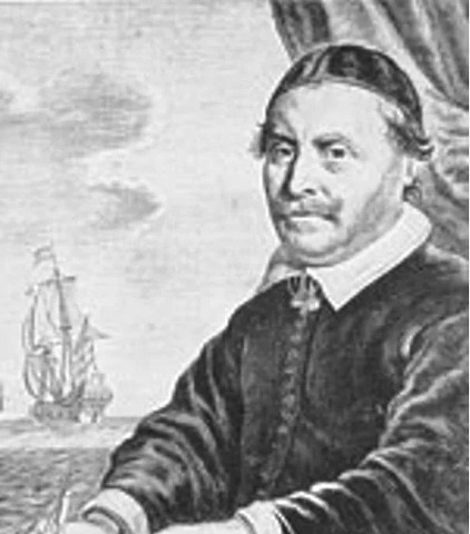
Janssonius, Johannes
Johann Janssonius (1588 in Arnhem - 1664 in Amsterdam; eigentlich Jan Janszoon) war ein niederländischer Kartograph, Verleger und Hersteller von Globen. Geboren in Arnheim, wo sein Vater Buchhändler und Verleger war (Jan Janszoon der Ältere). Im Jahr 1612 heiratete er die Tochter des Kartographen und Verlegers Jodocus Hondius und ließ sich dann in Amsterdam als Buchverleger nieder. Im Jahr 1616 veröffentlichte er seine ersten Karten von Frankreich und Italien, und von da an produzierte er eine große Anzahl von Karten, die vielleicht nicht ganz mit denen der Familie Blaeu mithalten konnten, aber in Bezug auf Quantität und Qualität sehr nahe dran waren. Von etwa 1630 bis 1638 arbeitete er mit seinem Schwager Henricus Hondius zusammen und gab weitere Ausgaben der Mercator/Hondius-Atlanten heraus, denen sein Name hinzugefügt wurde. Nach dem Tod von Henricus Hondius übernahm er das Geschäft und baute den Atlas weiter aus, bis er schließlich einen 11-bändigen Atlas Major herausgab, der einen ähnlichen Umfang wie der Atlas Major von Blaeu hatte.
- Janssonius, Johannes Legionis Regnum et Asturiarum PrincipatusBestell-Nr .: 01830
"Legionis Regnum et Asturiarum Principatus". Copper-engraving by J. Janssonius published by P. Schenk & G. Valk, ca. 1700. Original old colouring. With 2 ornamental cartouches. 37:47,5 cm (14 1/2 x 18 3/4 inch.).
Verkauft - Janssonius, Johannes Lochabria, omnesque, Insulae verus...Bestell-Nr .: 09354
Westschottland. "Lochabria, omnesque, Insulae verus Occidentem sitae, ut Uisto Mulla aliaeque". Orig. copper-engraving published by G. Valck and P. Schenk in Amsterdam, ca. 1700. 43,5:52 cm.
Verkauft - Janssonius, Johannes Lorna, Knapdalia, Cantire, Iura, Ila,...Bestell-Nr .: 01860
"Lorna, Knapdalia, Cantire, Iura, Ila, Glota, et Buthe Insulae". Copper-engraving by J. Janssonius published by P. Schenk & G. Valk, ca. 1700. Original old colouring. With decorative figure title-cartouche. 43,5:52,5 cm (17 x 20 3/4 inch.).
Verkauft - Janssonius, Johannes Magni Ducatus Lithuaniae descripBestell-Nr .: 01875
"Magni Ducatus Lithuaniae ... descrip". Copper-engraving by J. Janssonius published by P. Schenk & G. Valk, ca. 1700. Original old colouring. With small title cartouche and 3 tables of explanations, 2 inset strip maps of the river Dnieper from...
Verkauft - Janssonius, Johannes Magni Mogolis ImperiumBestell-Nr .: 02379
Indien."Magni Mogolis Imperium". Altkol. Kupf.-Kte. nach J. Janssonius bei P. Schenk & G. Valk, um 1710. Mit 2 ausgem. fig. und ornament. Kart und Tierstaffage. 36,5:49 cm.
Verkauft - Janssonius, Johannes Marchia Nova - Vulgo New Marck in March:...Bestell-Nr .: 07995
"Marchia Nova- Vulgo New Marck in March: Brandenburg:". Altkol. Kupf.-Kte. von J. Janssonius bei P. Schenk und G. Valk, Amsterdam, ca. 1700. Mit 2 kol. fig. Kart.. 39:50,5 cm.
Verkauft - Janssonius, Johannes Momonia et LageniaBestell-Nr .: 04692
"Momonia et Lagenia". Copper-engraving from J. Janssonius' Atlas Minor, 1648-51. With ornamental title-cartouche, another cartouche with "Miliaria Hibernica", sea-monster and German heading title ("Von Irrlandt") above the map. 13,5:19,5 cm.
Verkauft - Janssonius, Johannes Nobilis Fluvius AlbisBestell-Nr .: 00318
Elbe. "Nobilis Fluvius Albis". Altkol. Kupf.-Kte. von J. Janssonius, (um 1650). Kte. in zwei Teilen übereinander mit ausgem. ornament. Titelkart., ausgem. fig Meilanzeiger u. kol. Ansicht von Hamburg (ca. 5,5:25,5 cm). 39:53 cm.
Verkauft - Janssonius, Johannes Nova Barbariae descriptioBestell-Nr .: 00360
Nordafrika."Nova Barbariae descriptio". Altkol. Kupf.-Kte. bei J. Janssonius (1588-1664), um 1650. Mit 2 ausgem. fig. u. herald. Kart. u. reicher Tierstaffage. 35,5:52 cm.
Verkauft - Janssonius, Johannes Nova et accurata descriptio totius Fioniae...Bestell-Nr .: 17955
Fünen (Dänemark)."Nova et accurata descriptio totius Fioniae vulgo Funen". Altkol. Kupf.-Kte. (von J. Janssonius) bei G. Valk & P. Schenk, um 1710. Mit 2 ausgem. fig. Kart., farb. Wappen u. Segelschiff. 40:50,5 cm.
Verkauft - Janssonius, Johannes Nova et accurata descriptio totius Fioniae...Bestell-Nr .: 01193
Dänemark - Fünen, Als und Langeland. "Nova et accurata descriptio totius Fioniae vulgo Funen". Altkol. Kupf.-Kte., J. Janssonius bei G. Valk & P. Schenk in Amsterdam, um 1700. Mit 2 ausgem. fig. Kart., farb. Wappen u. Segelschiff. 40:50,5 cm.
Verkauft - Janssonius, Johannes Nova et Accurata Poli Arctici ... descriptioBestell-Nr .: 06975
Nordpol (Arktis). "Nova et Accurata Poli Arctici ... descriptio". Orig. copperplate engraving, J. Janssonius. Published by. P. Schenk and G. Valk in Amsterdam, ca. 1690. Original old colouring. 41:52,5 cm.
Verkauft - Janssonius, Johannes Nova et accurata tabula Episcopatuum...Bestell-Nr .: 01187
Norwegen. "Nova et accurata tabula Episcopatuum Stavangriensis, Bergensis et Asloiensis". Altkol. Kupf.-Kte. (von J. Janssonius) bei G. Valk & P. Schenk, um 1710. Mit 2 ausgem. fig. u. onament. Kart., farb. Wappen, Segelschiffen u. Windrose. 40:49 cm.
Verkauft - Janssonius, Johannes Nova Helvetia TabulaBestell-Nr .: 20919
Schweiz. "Nova Helvetia Tabula". Orig. Kupf.-Kte., J. Janssonius, Amsterdam, 1648-51. Mit ornament. Titelkart., Kart. mit Meillenanzeiger ("Milliaria helvetica comm.") und dt. Titel ("Von Schweitzerland") oben. 14,5:19,5 cm.
Verkauft - Janssonius, Johannes (Autor) Lubin, Eilhard (Andere Autoren) Nova illustrissimi Ducatus Pomeraniae tabulaBestell-Nr .: 00576
Pommern. "Nova illustrissimi Ducatus Pomeraniae tabula". Kol. Kupf.-Kte. nach E. Lubin bei J. Janssonius, am 1640. Mit 4 ausgem. Kart., gr. ausgem. Wappen und reicher maritimer Staffage. 38:49,5 cm.
Verkauft - Janssonius, Johannes Palatinatus Posnaniensis in maiori Polonia...Bestell-Nr .: 01881
"Palatinatus Posnaniensis in maiori Polonia primarii nova delineatio". Altkol. Kupf.-Kte. von "G.F.M." bei P. Schenk & G. Valk, um 1710. Mit 2 fig. Kart., Widmung u. Wappen. 45:52 cm.
Verkauft - Janssonius, Johannes Paragvay, ó prov. de Rio de la Plata cumBestell-Nr .: 22651
Paraguay. "Paraguay, ó prov. de Rio de la Plata cum regionibus adiacentibus Tucuman et Sta. Cruz de la Sierra". Orig. copper-engraving. J. Janssonius, 1630. Orig. old colouring. With great ornamental title-cartouche with the...
Verkauft - Janssonius, Johannes Parte Alpestre dello Stato di Milano Con...Bestell-Nr .: 01845
"Parte Alpestre dello Stato di Milano Con il Lago Maggiore di Lugano, e di Como". Copper-engraving by J. Janssonius published by P. Schenk & G. Valk, ca. 1700. Original old colouring. With decorative figure title-cartouche and another ornamental...
Verkauft - Janssonius, Johannes Pascaarte van`t Oostelyckste deel vande...Bestell-Nr .: 00581
Mittelmeer. "Pascaarte van`t Oostelyckste deel vande Middelandsche Zee. Tabula hydrographica de partibus Orientalioribus Maris Mediterranei". Orig. copperplate engraving published by J. Janssonius, Amsterdam, 1650. Original old colouring. 42:54,5 cm.
Verkauft - Janssonius, Johannes Polesino di RovigoBestell-Nr .: 01833
"Polesino di Rovigo". Copper-engraving by J. Janssonius, published by P. Schenk & G. Valk, ca. 1700. Original old colouring. With 2 figure and ornamental cartouches. 37:47,5 cm (14 1/2 x 18 3/4 inch.).
Verkauft - Janssonius, Johannes Principato Citra olim PicentiaBestell-Nr .: 01839
"Principato Citra olim Picentia". Copper-engraving by J. Janssonius published by P. Schenk & G. Valk, ca. 1700. Original old colouring. With decorative figure title-cartouche. 37:48 cm (14 1/2 x 19 inch.).
Verkauft - Janssonius, Johannes Quarta pars Brabantiae cujus caput SylvaducisBestell-Nr .: 00653
's-Hertogenbosch. "Quarta pars Brabantiae cujus caput Sylvaducis". Altkol. Kupf.-Kte. nach W. van der Burgt bei J. Janssonius, um 1635. Mit ausgem. fig. Kart., 2 gr. farb. Wappen in den Oberecken sowie seitl. Leisten mit je 3 farb. Stadtwappen. 41,5:52,5 cm.
Verkauft - Janssonius, Johannes Regni Norvegiae nova et accurata descriptioBestell-Nr .: 01217
Norwegen. "Regni Norvegiae nova et accurata descriptio". Altkol. Kupf.-Kte., J. Janssonius bei G. Valk & P. Schenk, Amsterda, um 1700. 42,5:53,5 cm.
Verkauft - Janssonius, Johannes Reipublicae Genuensis ducatus et dominii....Bestell-Nr .: 00632
Republik Genua. "Reipublicae Genuensis ducatus et dominii. nova descrip.". Altkol. Kupf.-Kte. bei J. Janssonius, 1630. Mit gr. Titelkart. 37:48,5 cm.
Verkauft - Janssonius, Johannes Romagna olim FlaminiaBestell-Nr .: 01854
"Romagna olim Flaminia". Copper-engraving by J. Janssonius published by P. Schenk & G. Valk, ca. 1700. Original old colouring. With decorative figure title-cartouche and another ornamental cartouche. 37:47,5 cm (14 1/2 x 18 3/4 inch.).
Verkauft - Janssonius, Johannes SaltzburgBestell-Nr .: 15189
Salzburg. "Saltzburg". Orig. Kupferstich, J. Janssonius, 1657. Vogelschauansicht von Salzburg. Mit Titelkart., Kart. mit Erklärungen (A.-Z.), gr. Wappen und Windrose. 38:48 cm.
Verkauft - Janssonius, Johannes Septentrionalium Terrarum descript.Bestell-Nr .: 08952
Nordpol (Arktis)."Septentrionalium Terrarum descript.". Orig. copper-engraving from Atlas Minor. Published by J. Janssonius in Amsterdam, 1648-51. With ornamental title-cartouche and printed Latin heading title ("Polvs Arcticvs"). 14,5:20,5 cm.
Verkauft - Janssonius, Johannes Suchuen - et XensiBestell-Nr .: 06933
"Suchuen- et Xensi". Orig. copper-engraving by J. Janssonius, published by P. Schenk and G. Valk in Amsterdam, ca. 1690. Orig. old colouring. With figure title-cartouche, explanatory notes ("Notarum Explicatio") and another figure cartouche with...
Verkauft - Janssonius, Johannes Tabula Leogi et Haraiae ac Skiae vel...Bestell-Nr .: 18072
Skye und Lewis-Harris (Hebriden - Schottland). "Tabula Leogi et Haraiae ac Skiae vel Skianae Insularum". Orig. copperplate engraving, J. Janssonius. Published by P. Schenk and G. Valk in Amstradam, ca. 1690. Original old colouring. 44,5:52 cm.
Verkauft - Janssonius, Johannes Tabula Leogi et Haraiae ac Skiae vel...Bestell-Nr .: 10434
Skye und Lewis-Harris (Hebriden - Schottland). "Tabula Leogi et Haraiae ac Skiae vel Skianae Insularum". Orig. copperplate engraving, J. Janssonius. Published by P. Schenk and G. Valk in Amstradam, ca. 1690. Original old colouring. 44,5:52 cm.
Verkauft - Janssonius, Johannes Tabula Magellanica, qua Tierra del FuegoBestell-Nr .: 00119
Magellanstraße und Feuerland. "Tabula Magellanica, qua Tierra del Fuego". Orig. Kupferstich Karte, J. Janssonius bei P. Schenk & G. Valck, Amsterdam, ca. 1700. 41:52,5 cm.
Verkauft - Janssonius, Johannes Territorio di Brescia et di CremaBestell-Nr .: 01848
"Territorio di Brescia et di Crema". Copper-engraving by J. Janssonius published by P. Schenk & G. Valk, ca. 1700. Original old colouring. With decorative figure title-cartouche and another ornamental cartouche. 38,5:48,5 cm (15 1/4 x 19 inch.).
Verkauft - Janssonius, Johannes Territorio di VeronaBestell-Nr .: 01842
"Territorio di Verona". Copper-engraving by J. Janssonius published by P. Schenk & G. Valk, ca. 1700. Original old colouring. With 2 decorative figure and ornamental cartouches. 37:48 cm (14 1/2 x 19 inch.).
Verkauft - Janssonius, Johannes Tractuum Borussiae, circa Gedanum et...Bestell-Nr .: 01857
"Tractuum Borussiae, circa Gedanum et Elbingam, ab incolis Werder appelati, cum adiuncta Neringia, nova et elaboratißima delineatio". Altkol. Kupf.-Kte. nach O. J. Gothus von P. Schenk & G. Valk. Mit ornament. Kart. 40,5:47,5 cm.
Verkauft - Janssonius, Johannes TransylvaniaBestell-Nr .: 08253
"Transylvania". Orig. copper-engraving. Published by J. Janssonius in Amsterdam, 1648-51. With ornamental title-cartouche and printed German heading-title ("Transylvania oder Siebenburgen"). 14:20 cm.
Verkauft - Janssonius, Johannes Turcicum ImperiumBestell-Nr .: 18702
Naher Osten."Turcicum Imperium". Orig. copper-engraving. J. Janssonius, Amsterdam, 1636. Original old colouring. With graet figure title-cartouche and 2 ships. 41:52 cm.
Verkauft - Janssonius, Johannes Turcicum ImperiumBestell-Nr .: 00684
Naher Osten, Türkei. "Turcicum Imperium". Orig. copperplate engraving, J. Janssonius, 1636. Original outline colouring. With 2 coloured figure title-cartouche. 41:52 cm.
Verkauft - Janssonius, Johannes Typus Maritimus Groenlandiae, Islandiae, ...Bestell-Nr .: 24778
Nordatlantik, Grönland, Island. "Typus Maritimus Groenlandiae, Islandiae, ...". Orig. coppreplate engraving, J. Janssonius, Amsterdam, ca. 1680. Old colouring. With fgure title cartouche, a cartouche with the scale of map, 2 wind roses, 2 sailing ships and a sea creature. 43:54 cm.
Verkauft - Mercator, Gerardus (Autor) Janssonius, Johannes (Andere Autoren) Walachia, Servia, Bulgaria, RomaniaBestell-Nr .: 25612
Ostbalkan. "Walachia, Servia, Bulgaria, Romania". Orig. copperplate engraving after G. Mercator's map of the region. Published by J. Janssonius and H. Hondius, Amsterdam, 1638. Coloured. 34,5:47 cm.
Verkauft - Janssonius, Johannes Zandvliet - Antwerpen - Tabula Castelli ad...Bestell-Nr .: 01322
Zandvliet - Antwerpen. "Tabula Castelli ad Sandflitam, qua simul inundati agri, alluviones, foßae, alvei, quae Bergas ad Zomam et Antverpiam interjacent, annotantur". Orig. copperplate engraving. Published in Amsterdam by Janssonius van Waesberge, M. Pitt and S. Swart,...
Verkauft


