Keine Artikel
Kategorien
- Alte Landkarten und Stadtansichten
- Afrika
- Amerika
- Amerika (Kontinent)
- Antillen
- Argentinien
- Bermudainseln
- Brasilien
- Chile
- Florida
- Guyana
- Hawaiiinseln
- Honduras
- Kalifornien
- Kanada
- Kolumbien
- Louisiana
- Magellanstraße
- Mexico
- Mittelamerika und Antillen
- Neuengland
- New York
- Nordamerika
- Nordkaroline
- Panama
- Paraguay
- Pennsylvania
- Peru
- Südamerika
- Uruguay
- Venezuela
- Vereinigte Staaten (USA)
- Alabama
- Arkansas
- Boston
- Connecticut
- Florida
- Georgia
- Illinois
- Iowa
- Kentucky
- Louisiana
- Maine
- Maryland und Delaware
- Massachusetts und Rhode Island
- Michigan
- Mississippi
- Missouri
- New Hampshire und Vermont
- New Jersey
- New York
- Ohio
- Ostküste von USA
- Pennsylvania
- Philadelphia
- Rhode Island
- South Carolina
- Tennessee
- Texas
- Virginia
- Wisconsin
- Virginia
- Asien und Australien
- Asien (Kontinent)
- Australien
- Burma
- China
- Französisch-Polynesien
- Golf von Bengalen
- Indien
- Indien, China, Nepal
- Indischer Ozean
- Indonesien
- Israel / Palästina
- Japan
- Kaspische Meer
- Korea
- Malaysien
- Mikronesien
- Naher Osten
- Neuseeland
- Nordostasien
- Ostasien
- Pakistan
- Philippinnen
- Polynesien
- Sri Lanka (Ceylon)
- Südostasien
- Südwestasien
- Türkei
- Atlases
- Europa
- Belgien, Niederlande, Luxemburg
- Alkmaar
- Amsterdam
- Antwerpen
- Arnhem
- Belgien und Luxemburg
- Bergen op Zoom
- Blokzijl
- Bommenede
- Brabant
- Breda
- Brielle
- Brugge
- Brüssel
- Charleroi
- Delft
- Den Haag
- Dinant
- Doornik
- Dordrecht
- Drenthe
- Drenthe und Overijseel
- Elburg
- Flandern
- Fort Rammekens
- Friesland
- Friesland und Groningen
- Geertruidenberg
- Gelderland
- Geraardsbergen
- Grave
- Groningen
- Haarlem
- Hainaut
- Hannut
- Harderwijk
- Harlingen
- Holland
- Hulst
- Huy
- Kortryk
- Leeuwarden
- Leiden
- Lier
- Limbourg
- Limburg
- Löwen
- Lüttich
- Luxemburg
- Luxemburg (Stadt)
- Maastricht
- Mechelen
- Menin
- Middelburg
- Mons
- Namur
- Niederlande
- Niederlande und Belgien
- Nijmegen
- Ostende
- Overijssel
- Rotterdam
- Ruremonde
- s-Hertogenbosch
- Spa
- Stavoren
- Steenwijk
- Tiel
- Utrecht
- Veere
- Veurne
- Vlissingen
- Ypern
- Zaltbommel
- Zeeland
- Zieriksee
- Zierikzee
- Zutphen
- Zwolle
- Zype
- Böhmen, Mähren, Schlesien und Lausitz
- Adršpach
- Andělská Hora (hrad)
- Arnau
- Aussig
- Bad Liebwerda
- Bechyňsko
- Beraun
- Berounsko
- Berounsko a Plzeňsko
- Bílina
- Blansko
- Blatná
- Böhmen
- Böhmen, Mähren und Schlesien
- Bollechowitz
- Bömisch Aicha
- Borotín
- Bösig
- Boskovice
- Bouzov
- Brandýs nad Labem
- Branná (okr. Šumperk)
- Břeclav
- Březnice
- Brněnsko
- Brněnsko a Uherskohardišťsko
- Brodce (okr. Mladá Boleslav)
- Broumov
- Brtnice
- Brünn
- Budeč (hradiště)
- Budweis
- Bürglitz
- Buštěhrad
- Buzice (tvrz)
- Čáslav
- Čáslavsko
- Čelákovice
- Česká Lípa
- České Švýcarsko
- Český Brod
- Český Krumlov
- Český Šternberk
- Cheb
- Chebsko a Žatecko
- Chlum (okr. Kutná Hora)
- Chlum Svaté Máří
- Chlumec nad Cidlinou
- Chodová Planá
- Chomutov
- Choustníkovo Hradiště (zřícenina hradu)
- Chrudim
- Chrudimsko
- Chrudimsko, Čáslavsko, Kouřimsko
- Děčín
- Dívčí Hrad
- Doksany (okr. Litoměřice)
- Dolní Olešnice - Nové Zámky
- Dolní Životice (okr. Opava)
- Doupov
- Dubí
- Duchcov
- Dvojhradí (Mstišov)
- Dvůr Králové nad Labem
- Eger - und Elbogenland
- Egerberg
- Egerberk (Klášterec nad Ohří)
- Felixburg (Klášterec nad Ohří)
- Františkovy Lázně
- Frauenberg in Böhmen
- Frenštát pod Radhošťem
- Friedrichsthal
- Frýdlant
- Graupen
- Habrovany
- Hartenberg (Hřebeny, okr. Sokolov)
- Hassenstein
- Hauenštejn (Horní hrad, okr. Karlovy Vary)
- Házmburk
- Helfštýn
- Herrnskretschen
- Hlavačov (Hlaváčov, Rakovník)
- Hohenelbe
- Hořice (v Podkrkonoší)
- Hradec Králové
- Hranice na Moravě
- Hrubá Skála
- Hukvaldy
- Jáchymov
- Jankov
- Jánský Vrch
- Jánský Vrch (Javorník)
- Jaromirsch
- Jenstein
- Jeseník
- Jestřebí
- Jezeří
- Jičín
- Jihlava
- Jižní Čechy
- Johannesbad
- Kaceřov (Plzeň-sever)
- Kadaň
- Kamaick
- Karlsbad
- Karlstein
- Kasejovice - Řesanice
- Klabava (Ejpovice, okr. Rokycany)
- Kladno
- Kladruby
- Klatovy
- Kokořín
- Kolín
- Kondrac
- Konojedy (u Litoměřic)
- Konopiště
- Kopidlno (okr. Jičín)
- Kost
- Kostelec nad Labem
- Kostenblatt
- Kouřimsko
- Krakovec
- Králíky
- Královéhradecko
- Krásný Dvůr (okr. Louny)
- Krašov (hrad)
- Kratochvíle (zámek)
- Křečov (okr. Louny)
- Křepenice
- Krkonoše
- Krnov
- Kroměříž
- Krušné hory
- Kuks
- Kumburk
- Kunětická Hora
- Kunžvart (Šumava)
- Kuttenberg
- Kynšperk nad Ohří
- Kynžvart (zámek)
- Kyselka
- Kyšperk
- Lanšperk
- Laun
- Ledeč nad Sázavou
- Lednice
- Libá (okr. Cheb)
- Libějovice
- Liberec
- Liběšice
- Liblín (okr. Rokycany)
- Libochovany
- Libochovice
- Libštejn
- Lina (Vroutek, okr. Louny)
- Lipnice nad Sázavou
- Litoměřice
- Litoměřicko
- Litomyšl
- Littitz
- Lobositz
- Loket
- Luhačovice
- Lysá nad Labem
- Mähren
- Marienbad
- Melnik
- Mikulov
- Milčany
- Milešov (Velemín)
- Milešovka
- Miletín
- Milíčeves (okr. Jičín)
- Mladá Boleslav
- Mladoboleslavsko
- Mladoboleslavsko a Litoměřicko
- Mnichovo Hradiště
- Most
- Mšec
- Mühlhausen an der Moldau
- Mürau
- Náchod
- Napajedla
- Návarov
- Nepomuk
- Neuhaus
- Nimburg
- Nové Hrady (okr. Ústí nad Orlicí)
- Nový Bor
- Okoř
- Olmütz
- Olomoucko
- Ondrášov (Moravský Beroun)
- Opava
- Orlík nad Vltavou
- Osek
- Ostrov nad Ohří
- Pardubice
- Patzau
- Pavlov
- Pecka (hrad)
- Pernstein
- Petrohrad (Petršpurk, okr. Louny)
- Písek
- Plaňany
- Plasy
- Plzeň
- Plzeňsko
- Podiebrad
- Polná
- Prachatice
- Prácheňsko
- Prag
- Praha - Cheb
- Praha a okolí
- Prerau
- Přerovsko
- Pressnitz
- Proboštov
- Proseč u Pošné (okr. Pelhřimov)
- Protivín
- Przelautsch
- Pullitz
- Raabstein
- Rabí
- Račice (Vyškov)
- Radim (okr. Kolín)
- Rájec nad Svitavou
- Rajhrad
- Rakovnicko
- Rakovník
- Ronov (okr. Česká Lípa)
- Ronov nad Sázavou
- Rosstein
- Roudnice nad Labem
- Rožmberk nad Vltavou
- Rožnov pod Radhoštěm
- Rudolfov (České Budějovice)
- Rychmburk
- Rychnov nad Kněžnou
- Rýzmburk (hrad)
- Rzeczkowitz
- Schellenberg
- Schlan
- Schreckenstein
- Schwamberg
- Sedlec
- Severní Čechy
- Skuteč
- Slavkov u Brna
- Sloup (hrad)
- Smečna
- Smidary (okr. Hradec Králové)
- Smirschitz
- Sovinec (hrad)
- Šternberk (Ledce)
- Strakonice
- Štramberk
- Šumava
- Šumburk (Šumná)
- Šumperk
- Svatý Jan pod Skalou
- Svojanov (hrad)
- Svojšice
- Tábor
- Táborsko a Českobudějovicko
- Tachov
- Telenice - Varvažov
- Teplá
- Teplice
- Theresienstadt
- Toužetín
- Třebel
- Třeboň
- Trhanov (okr. Domažlice)
- Trosky
- Tuchoraz
- Týn nad Vltavou
- Týnec nad Labem
- Uherské Hradiště
- Újezdec (hrad)
- Uničov
- Úvaly
- Valdštejn
- Valkeřice
- Valtice
- Vartenberk - Stráž pod Ralskem (okr. Česká Lípa)
- Velehrad
- Velhartice
- Velké Meziříčí
- Velké Žernoseky
- Veveří
- Vinec
- Višňová (okr. Liberec)
- Vlastislav
- Vlkava
- Vltava
- Vrabinec
- Vřeskovice
- Východní a Severovýchodní Čechy
- Vysoké Mýto
- Vyšší Brod
- Wegstädtl
- Winterberg
- Žacléř
- Zahájí
- Zákupy
- Žampach (zámek)
- Zámrsk
- Západní Čechy
- Žatec
- Žatecko
- Žebrák a Točník
- Želiv
- Žireč
- Žleb
- Zlenice (Hláska)
- Znojemsko a Jihlavsko
- Znojmo
- Zornstein
- Zvíkov
- Zvířetice
- Deutschland
- Donau
- Europa (Kontinent)
- Frankreich
- Albi
- Anjou
- Arras
- Artois
- Auvergne
- Avignon
- Bar-le-Duc
- Beauce
- Beauvais
- Berry
- Blois
- Bordeaux
- Bourbonnais
- Bourbourg
- Bresse
- Brie
- Burgund-Freigrafschaft
- Calais
- Cambrai
- Cassel
- Champagne
- Château de Lichtenberg
- Chaumont
- Compiegne und Noyon
- Dauphiné
- Département Tarn
- Dombes
- Douai
- Dünkirchen
- Elsass
- Fontainebleau
- Gascogne
- Gâstinais and Senonais
- Gravelines
- Hauts-de-France
- Hondschoote
- Ile de France
- Iles de Lérins
- Korsika
- La Bassée - Hesdin
- La Rochelle
- Languedoc
- Lille
- Limoges
- Lothringen
- Lyon
- Maine
- Marseille
- Metz
- Montmélian
- Mülhausen
- Nancy
- Nevers
- Nice
- Normandie
- Orange
- Paris
- Perche
- Perpignan
- Picardie
- Poitou
- Provence
- Quercy
- Re und Oleron
- Reims - Rethel
- Rethel
- Saint-Germain-en-Laye
- Saint-Omer
- Saintonge und Aunis
- Sarlat
- Savoyen
- Savoyen und Osten Burgund (Franche - Comte)
- Strassburg
- Südfrankreich
- Südostfrankreich
- Thérouanne
- Touraine
- Valenciennes
- Vexin
- Westfrankreich
- Wissembourg
- Griechenland, Mittelmeer
- Grossbritannien und Irland
- Bedford und Buckinghamshire
- Berkshire und Hampshire
- Cambridgeshire
- Cheshire
- Cornwall
- Cumberland
- Denbigh und Flint
- Derbyshire
- Devon
- Dorset
- Durham (Grafschaft)
- England
- Essex
- Exeter
- Gloucestershire
- Großbritannien und Irland
- Hampshire
- Herefordshire
- Hertfordshire
- Hertfordshire and Middlesex
- Holy Island und Farne Island
- Huntingdonshire
- Irland
- Isle of Man
- Isle of Wight
- Kent
- Lancashire
- Leicestershire
- Lincolnshire
- London
- Middlesex
- Nordengland
- Nordostengland
- Nordwestengland
- Norfolk
- Northampton
- Northumberland
- Nottinghamshire
- Orkneys und Shetland
- Oxfordshire
- Portsmouth
- Rutland
- Schottland
- Shropshire
- Shropshire und Staffordshire
- Somerset
- Staffordshire
- Südostengland
- Südwestengland
- Surrey
- Sussex
- Wales
- Westmorland
- Wiltshire
- Worcestershire und Warwickshire
- Yorkshire
- Italien
- Abruzzen
- Acquapendente
- Ancona
- Apulien (Puglia)
- Arcevia
- Assisi
- Bari und Basilikata
- Belluno und Feltre
- Bergamo
- Bologna
- Bracciano
- Brescia
- Brescia und Crema
- Cadore
- Cagliari
- Caiazzo
- Camerino
- Capitanata
- Carmagnola
- Catania
- Civitavecchia
- Crema
- Cremona
- Cuneo
- Elba
- Emilia Romagna
- Faenza
- Fano
- Ferrara
- Florenz
- Fondi
- Friaul
- Gaeta
- Gallipoli
- Genua
- Ischia
- Italien
- Kalabrien
- Kampanien
- Lago di Como
- Lago Maggiore
- Lazio
- Lerici
- Ligurien (Italienische Riviera)
- Livorno
- Lombardei
- Loreto
- Lucca
- Mailand
- Mantua
- Mantua
- Marche (Ancona)
- Meran
- Messina
- Mirandola
- Mittelitalien
- Modena
- Molise
- Monferrato
- Neapel
- Netuno
- Nocera Umbra
- Norditalien
- Orvieto
- Orvieto und Loreto
- Otranto
- Padua
- Palermo
- Parma
- Parma und Piacenza
- Pavia
- Perugia
- Pesaro
- Piacenza
- Piemont
- Pinerolo
- Piombino
- Pisa
- Po
- Pozzuoli
- Puglia und Calabria
- Ravenna
- Reggio di Calabria
- Reggio Emilia
- Rimini
- Rom
- Romagna
- Rovereto
- Rovigo
- San Marino
- Sardinien
- Siena
- Sizilien
- Sizilien und Malta
- Sizilien und Sardinien
- Spoleto
- Süditalien
- Sulmona
- Taranto
- Terracina
- Tirol
- Tivoli
- Tortona
- Toskana
- Trapani
- Trentino
- Trentino-Alto Adige / Südtirol
- Treviso
- Tricarico
- Triest
- Turin
- Udine
- Umbria
- Urbino
- Velletri
- Venedig
- Vercelli
- Verona
- Vicenza
- Viterbo
- Labe
- Mitteleuropa
- Mittelmeer
- Monaco
- Nordeuropa
- Österreich
- Ostsee
- Polen, Schlesien, Rußland, Blatikum
- Rhein
- Schweiz
- Skandinavien und Island
- Spanien und Portugal
- Andalusien
- Andalusien und Granada
- Aragonien
- Azoren
- Balearen
- Barcelona
- Barcelona und Ecija
- Burgos
- Cadiz
- Cordoba
- Extremadura
- Galizien
- Gibraltar
- Granada
- Kanarische Inseln
- Kastilien
- Katalanien
- Leon und Asturien
- Lissabon
- Madeira
- Madrid
- Navarra
- Nordostspanien
- Nordspanien
- Nordwestlichen Spanien
- Portugal
- Roses
- Sevilla
- Spanien
- Toledo und Valladolid
- Valencia
- Südost- und Osteuropa, Balkan
- Belgien, Niederlande, Luxemburg
- Inseln (Sonderkatalog)
- Welt, Ozeane, Pole und Sternbildkarten
- Bücher
- 17., 18. a 19. století - Bohemika, Moravika, České národní obrození
- 17., 18. und 19. Jhdt. - Literatur, Illustrierte etc. - Ausland
- 20. Jhdt. - Literatur, Poesie, Pressendrucke etc. - Ausland
- 20. Jhdt. - Literatur, Poesie, Pressendrucke, Buchbinderei etc. - Tschechisch
- Alte Drucke (15. - 16. Jahrhundert)
- Bildende Kunst und Architektur
- Geschichte und Recht
- Kinder- und Jugendbücher
- Kulturgeschichte, Varia
- Natur und Naturwissenschaften
- Philosophie, Theologie, Pädagogik, Ökonomie, Soziologie
- Topographie, Reisen und Geographie
- Graphik und Zeichnungen
- Alte Graphik, Zeichnungen und dekorative
- Alte Meistergrafik
- Devotionalien und kleine Gebrauchsgrafiken (Andachtsbilder, Glückwünsche usw.)
- Europeische moderne Kunst (Graphik, Ex-libris, Zeichnungen)
- Japanische Holzschnitte
- Tschechische Kunst des 20. Jhdt. (Graphik, Ex-libris, Zeichnungen)
- Balcar, Jiří (1929-1968)
- Bílek, František (1872-1941)
- Bím, Tomáš (1946)
- Born, Adolf (1930)
- Bouda, Cyril (1901-1984)
- Chadima, Jiří (nar. 1923)
- Demel, Karel
- Fischerová-Kvěchová, Marie (1892-1984)
- Gross, František (1909-1985)
- Hodek, Josef mladší (1888-1973)
- Holler, Josef (1903-1982)
- Hudeček, František (1909-1990)
- Jiřincová, Ludmila (1912-1994)
- Kobliha, František (1877-1962)
- Konůpek, Jan (1883-1950)
- Lada, Josef (1887-1957)
- Lhoták, Kamil (1912-1990)
- Malich, Karel (1924-2019)
- Mrkvicka, Otakar (1898-1957)
- Mucha, Alfons
- Obrátil, Karel Jaroslav
- Orlik, Emil (1870-1932)
- Preissig, Vojtěch
- Rambousek, Jan (1895-1976)
- Sekora, Ondřej (1899-1967)
- Seydl, Zdenek (1916-1978)
- Šimon, Tavík František (1877-1942)
- Sladek, Jan (1906-1982)
- Stretti, Viktor (1878-1957)
- Stretti-Zamponi, Jaromír (1882-1959)
- Švabinský, Max (1873-1962)
- Tichý, František (1896-1961)
- Tomanová, Emilie (1933-1994)
- Trnka, Jiří (1912-1969)
- Uprka, Joža (1861-1940)
- Váchal, Josef (1884-1969)
- Vik, Karel (1883-1969)
- Vondrouš, Jan Charles (1884-1970)
- Wenig, Josef (1885-1939)
- Zrzavý, Jan (1890-1977)
- Varia
Liste der Werke von Autor: Hondius, Jodocus
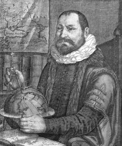
Hondius, Jodocus
Jodocus Hondius (eigentlich Joost de Hondt; 1563 in Wakken, Flandern 1612 in Amsterdam) war ein flämischer Kartograph und Verleger von Atlanten und Karten. 1600 fertigte er einen Himmelsglobus an, der zwölf neue Sternbilder des Südhimmels zeigte, die von dem niederländischen Navigator Pieter Dirkszoon Keyser entdeckt worden waren. Im Jahr 1604 kaufte Hondius die Druckplatten von Mercators Weltatlas Atlas sive cosmographicae meditationes de fabrica mundi et fabricati figura, der zu dieser Zeit an Popularität gegenüber dem Theatrum Orbis Terrarum von Abraham Ortelius zurückgefallen war. Hondius fügte ungefähr vierzig eigene Karten hinzu und veröffentlichte diese erweiterte Ausgabe ab 1606 unter dem Namen Mercators und seinem eigenen als Verleger. Dieser Atlas, der in mehreren Auflagen erschien, wird heute als Mercator-Hondius-Atlas bezeichnet. Kurz vor Hondius’ Tod heiratete seine Tochter Elisabeth den niederländischen Verleger Jan Jansson. Hondius' Verlag wurde nach 1612 von seiner Witwe und seinen Söhnen Jodocus II und Henricus weitergeführt. Ab 1633 war Jan Jansson als Geschäftspartner und Mitverleger an der weiteren Veröffentlichung des Atlas beteiligt.
- Hondius, Jodocus America meridionalisBestell-Nr .: 24769
Südamerika. "America meridionalis". Orig. copperplate engraving, J. Hondius, 1606. From Mercator - Hondius Atlas, published by H. Hondius in Amsterdam, 1630. With figure title cartouche, an ornamental cartouche with the view of Cusco and many other decorations (Indians, ships, sea monsters). 36:49 cm.
20 500,00 KčZu verkaufen - Hondius, Jodocus (Autor) Mercator, Gerardus (Andere Autoren) Amerika - Americae Descrip., Kupferstich...Bestell-Nr .: 26746
Amerika. "Americae Descrip.". Orig. copperplate engraving from Mercator's Atlas Minor. Published by J. Hondius in Amsterdam, 1607. With ornamental title cartouche with the scale of map. 15:19,5 cm.
7 000,00 KčZu verkaufen - Hondius, Jodocus Andaluziae Nova Descript.Bestell-Nr .: 25416
Andalusien. "Andaluziae Nova Descript.". Orig. Kupferstich Karte, J. Hondius, 1606. Bei H. Hondius in Amsterdam, 1630. Mit ornament. Titelkart. und Kart. mit Maßstab der Karte. 35,5:50,5 cm.
9 000,00 KčZu verkaufen - Hondius, Jodocus (Autor) Mercator, Gerardus (Andere Autoren) Anglesey Ins.. - Wight ol. Vectis. - Ins....Bestell-Nr .: 25535
Inseln Anglesey, Wight, Jarsey, Guernesey. "Anglesey Ins."; "Wight ol. Vectis"; "Ins. Garnesey"; "Ins. Iarsey". Orig. copperplate engraving from Mercator's Atlas Minor. Published in Amsterdam by J. Hondius in Amsterdam, 1609. 12,5:17 cm.
1 800,00 KčZu verkaufen - Hondius, Jodocus Arragonia et CataloniaBestell-Nr .: 25419
Aragonien und Katalonien. "Arragonia et Catalonia". Orig. Kupferstich Karte, J. Hondius, 1606. Bei H. Hondius, Amsterdam, 1630. Mit ornament. Titelkart. und Kart. mit Maßstab der Karte. 34,5:48,5 cm.
6 500,00 KčZu verkaufen - Mercator, Gerardus (Autor) Hondius, Jodocus (Andere Autoren) Čechy - Bohemia, mapa Čech, mědirytina,...Bestell-Nr .: 26902
Čechy. "Bohemia". Pův. mědirytina z Mercatorova Atlasu Minor. Vyd. J. Hondius, C. Claesz. a J. Jansz. v Amsterdamu, 1609. S ornament. titulní kartuší. 14:19,5 cm.
3 200,00 KčZu verkaufen - Hondius, Jodocus Cuba Insula - Hispaniola Insula - Insula...Bestell-Nr .: 00098
Antillen (Westindischen Inseln). "Cuba Insula. Hispaniola Insula. Insula Iamaica. Ins. S. Ioannis. I. S. Margareta". Orig. copper-engraving, J. Hondius, 1606. Coloured. 36:50 cm.
16 000,00 KčZu verkaufen - Mercator, Gerardus (Autor) Hondius, Jodocus (Andere Autoren) Die Welt - Designatio Orbis Christiani,...Bestell-Nr .: 26767
Die Welt (Thematische Karte). "Designatio Orbis Christiani". Orig. copperplate engraving from Mercator's Atlas Minor. Published by J. Hondius in Amsterdam, 1609. With ornamental title cartouche. 15:19 cm.
7 500,00 KčZu verkaufen - Hondius, Jodocus (Autor) Mercator, Gerardus (Andere Autoren) Eboracum, Lincolnia, Derbia, Stafford, etcBestell-Nr .: 25943
Nordostengland. "Eboracum, Lincolnia, Derbia, Stafford, etc.". Orig. copperplate engraving from Mercator's Atlas Minor. Published by J. Hondius in Amsterdam, 1607. With ornamental title cartouche. 13:17 cm.
1 600,00 KčZu verkaufen - Hondius, Jodocus Exquisita & magno ... Freti Magellanici...Bestell-Nr .: 00145
Magellanstraße. "Exquisita & magno ... Freti Magellanici Facies". Orig. Kupferstich Karte, G. Mercator und J. Hondius, 1606. Bei H. Hondius in Amsterdam, 1630. 35:46 cm.
15 000,00 KčZu verkaufen - Mercator, Gerardus (Autor) Hondius, Jodocus (Andere Autoren) Genfersee - Lacus Lemani, Kupferstich...Bestell-Nr .: 26941
Genfersee. "Lacus Lemani vicinorumq. locorum nova et accurata descriptio". Orig. altkol. Kupferstich, 1630 nach G. Mercators und J. Hondius Karte vom Region. Bei J. Janssonius in Amsterdam, 1636. Mit 3 ornament. Kart.. 38:49,5 cm.
10 500,00 KčZu verkaufen - Mercator, Gerardus (Autor) Hondius, Jodocus (Andere Autoren) Morava - Moravia, mapa, mědirytina,...Bestell-Nr .: 26904
Morava. "Moravia". Původní mědirytina podle G. Mercatorovy mapy Moravy. Vyd. J. Hondius v Amsterdamu, 1613. S ornamentální titulní kartuší. 13,5:17,5 cm
3 200,00 KčZu verkaufen - Hondius, Jodocus (Autor) Mercator, Gerardus (Andere Autoren) Northumbr. Cumberlandia Dunelm. Episcop.Bestell-Nr .: 25942
Nordengland. "Northumbr. Cumberlandia Dunelm. Episcop.". Orig. copperplate engraving from Mercator's Atlas Minor. Published by J. Hondius in Amsterdam, 1609. With ornamental title cartouche and French title above the map. 13,5:19 cm.
1 600,00 KčZu verkaufen - Hondius, Jodocus Novus Brasiliae TypusBestell-Nr .: 25187
Brasilien. "Novus Brasiliae Typus". Orig. kol. Kupferstich Karte, J. Hondius, 1629. Bei W. J. Blaeu, Amsterdam, 1630. Mit fig. Titelkart. und Nebenkarte (Baya de Todos os Sanctos). 38:50 cm.
16 000,00 KčZu verkaufen - Hondius, Jodocus (Autor) Mercator, Gerardus (Andere Autoren) Scotiae tabula II.Bestell-Nr .: 25938
Südschottland. "Scotiae tabula II.". Orig. copperplate engraving from Mercator's Atlas Minor. Published by J. Hondius in Amsterdam, 1609. With ornamental title cartouche, another cartouche with the scale of map and French title above the map. 13,5:18,5 cm.
2 400,00 KčZu verkaufen - Hondius, Jodocus (Autor) Mercator, Gerardus (Andere Autoren) Scotiae tabula III.Bestell-Nr .: 25939
Nordschottland. "Scotiae tabula III.". Orig. copperplate engraving from Mercator's Atlas Minor. Published by J. Hondius in Amsterdam, 1609. With ornamental title cartouche with the scale of map, a ship and French title above the map. 14,5:18,5 cm.
2 400,00 KčZu verkaufen - Hondius, Jodocus Turcici Imperii ImagoBestell-Nr .: 23462
Naher Osten. "Turcici Imperii Imago". Orig. copper-engraving, J. Hondius, 1606. Published by H. Hondius, 1630. With decorative title-cartouche. 36:48,5 cm.
15 000,00 KčZu verkaufen - Hondius, Jodocus (Autor) Mercator, Gerardus (Andere Autoren) Typus Orbis Terrarum, Africae descriptio,...Bestell-Nr .: 13923
Die Welt und die Kontinente. "Typus Orbis Terrarum" + "Africae descriptio" + "Americae descrip." + "Asia" + "Europa". Orig. copperplate engravings after G. Mercator's maps published by J. Hondius in Amsterdam, 1609.
50 000,00 KčZu verkaufen - Hondius, Jodocus (Autor) Mercator, Gerardus (Andere Autoren) Ultonia Oriental.Bestell-Nr .: 25937
Nordost Irland. "Ultonia Oriental.". Orig. copperplate engraving from Mercator's Atlas Minor. Published by J. Hondius in Amsterdam, 1607. With ornamental title cartouche with the scale of map, a ship and a sea monster. 13,5:16,5 cm.
2 100,00 KčZu verkaufen - Hondius, Jodocus (Autor) Mercator, Gerardus (Andere Autoren) Warwicum Northampton, Huntington Cantabr etc.Bestell-Nr .: 25940
Südostengland - London, Essex, Kent ... "Warwicum Northampton, Huntington Cantabr etc.". Orig. copperplate engraving from Mercator's Atlas Minor. Published by J. Hondius in Amsterdam, 1609. With ornamental title cartouche and French title above the map. 14:18 cm.
1 600,00 KčZu verkaufen - Hondius, Jodocus Fessae et Marocchi RegnaBestell-Nr .: 25418
Marokko und Kanarische Inseln. "Fessae et Marocchi Regna". Orig. Kupferstich Karte, J. Hondius, 1606. Bei H. Hondius, Amsterdam, 1630. Mit ornament. Titelkart., Kart. mit Nebenkarte und Kart. mit Maßstab der Karte. 35,5:48 cm.
Verkauft - Hondius, Jodocus Normandia DvcatvsBestell-Nr .: 20880
"Normandia Ducatus". Orig. Kupf.-Kte. von J. Hondius. Bei J. Janssonius, Amsterdam, 1648-51. Mit ornament. Titelkart., andere Kart. mit Meillenanzeiger ("Milliaria Germania Com. Milliaria Gallica Commun."), eine Windrose und dt. Titel ("Von...
Verkauft - Hondius, Jodocus Nova Africae tabulaBestell-Nr .: 15816
Afrika."Nova Africae Tabula. Auctore Jodoco Hondio". Orig. copper-engraving, J. Hondius (1563-1612), Amsterdam, first published 1606. With great ornamental title-cartouche, 5 sailing ships and 3 sea monsters. 37,5:50 cm.
Verkauft - Hondius, Jodocus Nova Africae tabulaBestell-Nr .: 00343
Afrika."Nova Africae Tabula. Auctore Jodoco Hondio". Orig. copper-engraving, J. Hondius (1563-1612), Amsterdam, first published 1606. Original old colouring. With great ornamental title-cartouche, 5 sailing ships and 3 sea monsters. 37,5:50 cm.
Verkauft - Hondius, Jodocus Pedemontana Regio, cum Genuensium...Bestell-Nr .: 02808
"Pedemontana Regio, cum Genuensium territorio et Montisfferrati Marchionatu.". Orig. copper-engraving by J. Hondius, published in Amsterdam, 1608. With ornamental cartouche and "Milliaria Italiaca" in upper left corner. 14,5:18 cm.
Verkauft - Hondius, Jodocus Portugalliae ... descriptioBestell-Nr .: 00579
Portugal. "Portugalliae, que olim Lusitania, novissima et exactissima descriptio". Orig. copperplate engraving by B. van Doetecum after F. Alvares Secco's map of Portugal from 1600. Published by J. Janssonius and H. Hondius in Amsterdam, 1633. 33,5:49,5 cm.
Verkauft - Hondius, Jodocus Sabaudia ducatus La SavoiéBestell-Nr .: 03660
Savoyen. "Sabaudia ducatus La Savoié". Altkol. Kupf.-Kte. von J. Hondius, um 1630. Mit ornament. Titelkart., Meilenzeiger in ornament. Kart. und Wappen. 37,5:49 cm.
Verkauft - Hondius, Jodocus Terra Sancta quae in Sacris Terra...Bestell-Nr .: 00884
Israel / Palästina. "Terra Sancta quae in Sacris Terra Promissionis ol: Palestina". Kol. Kupf.-Kte., J. Hondius, 1606. Bei H. Hondius in Amsterdam, 1630 (Mercator-Hondius Atlas). Mit 2 Rollwerkskart. u. maritimer Staffage. 36:50 cm.
Verkauft - Hondius, Jodocus Turcici Imperii imagoBestell-Nr .: 00687
Naher Osten. "Turcici Imperii imago". Orig. copperplate engraving, J. Hondius, 1606. Published by H. Hondius, 1633 (Mercator - Hondius Atlas). With title cartouche with portrait of "Sultan Mahumet Turcorum Imperat". 36,5:48,5 cm.
Verkauft - Hondius, Jodocus (Autor) Mercator, Gerardus (Andere Autoren) Westmorland, Castria, Cestria etcBestell-Nr .: 25941
Nordwestengland - Manchester, Liverpool ... "Westmorland, Castria, Cestria etc". Orig. copperplate engraving from Mercator's Atlas Minor. Published by J. Hondius in Amsterdam, 1607. With ornamental title cartouche. 13,5:18 cm.
Verkauft


